




























Key Takeaways
- GIS Software Market Growth: The global GIS software market is estimated at USD 19.37 billion in 2026 and projected to reach USD 39.8 billion by 2035, growing at an 8.33% CAGR.
- Cloud GIS and AI Adoption: Cloud GIS is projected to grow at a 19.2% CAGR through 2030, driven by cloud computing, AI-powered geospatial analytics, satellite imagery, and real-time location intelligence.
- Regional Growth and Industry Applications: North America holds over 39% of the global GIS software market in 2026, while Asia-Pacific is emerging as a fast-growing region, supported by smart cities, precision agriculture, transportation, and infrastructure development.
The global GIS (Geographic Information System) software market is estimated at USD 19.37 billion in 2026 and projected to reach USD 39.8 billion by 2035, growing at an 8.33% CAGR. Explore 103 GIS software statistics covering market growth, cloud adoption, AI-powered geospatial analytics, regional trends, industry applications, and future forecasts.
The global Geographic Information System (GIS) software market is experiencing significant transformation in 2026, driven by rapid advancements in artificial intelligence (AI), cloud computing, geospatial analytics, satellite imagery, and location intelligence technologies. As businesses, governments, and organizations increasingly rely on geographic data to improve decision-making, optimize operations, and manage infrastructure, GIS software has become an essential component of modern digital transformation strategies.
According to industry estimates, the global GIS software market is projected to reach USD 19.37 billion in 2026 and expand to USD 39.8 billion by 2035, representing a compound annual growth rate (CAGR) of 8.33%. Other market research forecasts suggest even faster expansion, with some estimates projecting annual growth rates exceeding 14%. Although market valuations vary depending on research methodologies and industry definitions, these projections collectively highlight the increasing commercial importance of geographic information systems across multiple industries.
Geographically, North America accounts for more than 39% of the global GIS software market in 2026, supported by extensive adoption across government agencies, utilities, transportation networks, and smart city initiatives. Meanwhile, Asia-Pacific is emerging as one of the fastest-growing regional markets, with some forecasts projecting a CAGR of approximately 15.95% through 2031. Rapid urbanization, infrastructure development, agricultural modernization, and government investments in geospatial technologies are contributing to this regional expansion.
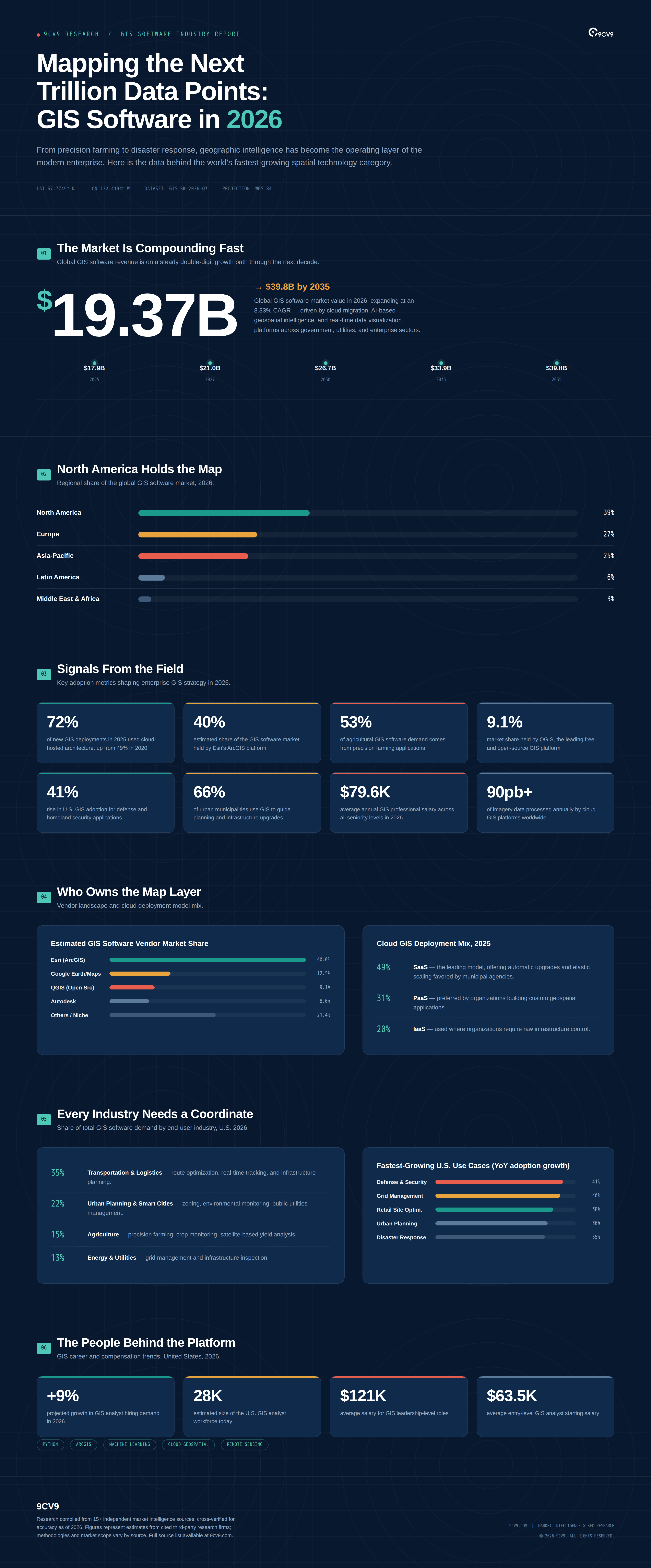
Cloud-based GIS software is another major growth driver reshaping the industry. One market estimate places the global cloud GIS market at USD 2.36 billion in 2026, with projected growth to USD 4.76 billion by 2030 at a CAGR of 19.2%. Furthermore, more than 72% of new GIS deployments in 2025 reportedly utilized cloud-hosted architectures, compared with 49% in 2020. This transition reflects growing demand for scalable, accessible, and cost-effective geographic information systems that support real-time data visualization, remote collaboration, and enterprise-wide spatial analytics.
The integration of artificial intelligence, machine learning, Internet of Things (IoT) technologies, and remote sensing is also expanding the capabilities of modern GIS platforms. Organizations increasingly use AI-powered geospatial analytics to identify geographic patterns, forecast environmental changes, monitor infrastructure, optimize transportation routes, and support predictive decision-making. The geospatial imagery analytics market alone was estimated at USD 13.56 billion in 2025 and is projected to reach USD 28.73 billion by 2033, highlighting the growing importance of automated spatial data processing.
Across industries, GIS software adoption continues to accelerate. Agriculture businesses are utilizing geographic information systems for precision farming, crop monitoring, and resource optimization, while transportation and logistics companies are implementing GIS-based route planning and supply chain management solutions. Government agencies are adopting geospatial technologies for disaster management, urban planning, environmental monitoring, and smart city development. Industry estimates suggest that approximately 66% of urban municipalities already use GIS technologies to support planning and infrastructure improvements.
The competitive GIS software landscape is evolving alongside these technological advancements. Established platforms such as Esri ArcGIS continue to maintain substantial market presence, with estimates placing Esri’s global GIS software market share at approximately 35%–40%. Meanwhile, open-source alternatives such as QGIS are expanding access to professional geographic information systems among small businesses, educational institutions, researchers, and public-sector organizations.
Despite these opportunities, the GIS software industry faces challenges involving high licensing costs, legacy system integration, data interoperability, cybersecurity, and shortages of specialized geospatial professionals. Approximately 42% of companies reportedly experience significant difficulties integrating modern GIS software with existing operational systems, emphasizing the importance of implementation planning and technical expertise.
Understanding the latest GIS software statistics, market size, adoption rates, industry trends, and growth forecasts for 2026 is essential for businesses, technology providers, investors, GIS professionals, and policymakers seeking to navigate this rapidly evolving market.
This comprehensive guide explores the top 103 GIS (Geographic Information System) software statistics, data, and trends in 2026, covering global market growth, regional market shares, cloud GIS adoption, leading software providers, artificial intelligence integration, industry-specific applications, GIS workforce trends, and software pricing. These insights provide a detailed overview of the current geospatial technology landscape and the developments expected to shape the future of geographic information systems through 2030 and beyond.
Before we venture further into this article, we would like to share who we are and what we do.
About 9cv9
9cv9 is a business tech startup based in Singapore and Asia, with a strong presence all over the world.
With over ten years of startup and business experience, and being highly involved in connecting with thousands of companies and startups, the 9cv9 team has listed some of the top and best companies/tools in this review.
If you like to get your company listed in our top B2B software reviews, check out our world-class 9cv9 Media and PR service and pricing plans here.
Top 103 GIS (Geographic Information System) Software Statistics, Data & Trends in 2026
Market Size & Growth
- The global GIS software market was estimated at USD 19.37 billion in 2026 and is projected to reach USD 39.8 billion by 2035 at an 8.33% CAGR. This steady long-term trajectory shows that GIS software is transitioning from a specialist tool into a mainstream enterprise technology category.
- A separate estimate values the GIS software market at USD 12.35 billion in 2026, growing to USD 21.98 billion by 2030 at a 14.4-15.5% CAGR. The wide variance between forecasts reflects differing market scope definitions, but all analysts agree the sector is expanding faster than the broader enterprise software industry.
- The broader Geographic Information System market (hardware, software, and services) is valued at USD 16.45 billion in 2026 and is expected to hit USD 50.94 billion by 2035, at a 13.38% CAGR. This wider figure illustrates how software increasingly anchors a much larger ecosystem of GIS-related hardware and consulting services.
- Another estimate places the total GIS market at USD 16.58 billion in 2026, rising to USD 31.8 billion by 2031 at a 13.94% CAGR. This forecast reinforces the consensus that GIS adoption is compounding at a double-digit pace through the early 2030s.
- The GIS market reached USD 16.0 billion in 2025 and is forecast to hit USD 39.4 billion by 2034, growing at a 10.21% CAGR. Rising demand from transportation, real estate, military, and agriculture sectors is cited as the primary catalyst behind this expansion.
- The GIS market was valued at approximately USD 11.8 billion in 2025 and is expected to grow at a 14.6% CAGR through 2035. Location-based intelligence adoption across industries continues to be the central driver referenced across independent forecasts.
- The U.S. GIS software market is projected to grow from USD 7.23 billion in 2024 to USD 21.33 billion by 2034, a CAGR of 11.43%. The scale of this domestic growth underscores America’s position as both the largest producer and consumer of GIS technology.
- The software component dominated the overall GIS market with a 51% share in 2025 and is expected to grow at roughly 13.3% CAGR through 2035. Software’s dominance over hardware and services confirms that spatial analytics capability, not data-capture equipment, is now the primary value driver in the category.
- The software segment is forecast to command as much as 62.6% of the total GIS market share by 2035. This growing dominance points to continued commoditization of GIS hardware alongside rising demand for advanced analytics and visualization platforms.
- The broader GIS tools market, valued at USD 34.2 billion in 2025, is projected to reach USD 62.8 billion by 2034 at a 7.5% CAGR. This figure includes surveying hardware and consulting alongside core software, offering a fuller picture of ecosystem-wide spending.
- Within the total GIS market, the services segment is forecast to grow fastest at a 15.45% CAGR, ahead of both software and hardware. Increasing reliance on managed support and cloud-migration consulting is fueling this faster services growth rate.
- The GIS software competitive landscape is described as concentrated, with enterprise deployments representing roughly 70% of total market value. This concentration highlights that large organizations, rather than individual users, remain the primary revenue source for GIS vendors.
Regional Market Share
- North America holds over 39% of the global GIS software market share in 2026. Advanced smart-city programs and strong utility-grid digitization continue to anchor the region’s leadership position.
- Europe accounts for approximately 27% of the global GIS software market. Green infrastructure initiatives and public transport optimization projects are cited as key regional growth drivers.
- Asia-Pacific contributes around 24-25% of the global GIS software market and is recognized as the fastest-growing region. Rapid urban expansion and large-scale infrastructure investment are propelling this accelerated regional growth.
- North America maintained a 37.80% share of the broader Geographic Information System market in 2025. This figure, drawn from a different market-scope analysis, corroborates North America’s consistent regional dominance across multiple independent studies.
- Asia-Pacific is set for the highest regional CAGR of 15.95% through 2031 in the broader GIS market. This growth rate substantially outpaces every other region tracked in the same forecast period.
- North America is projected to command a 38.6% share of the GIS market by 2035. Sustained public investment and federally mandated geospatial modernization programs support this long-term regional forecast.
- Asia Pacific is expected to expand at a 12.5% CAGR during 2026-2035, driven by government-backed digital infrastructure programs. Large-scale national spatial data initiatives across the region are central to this projected acceleration.
- China’s GIS software market is valued at roughly USD 680 million, representing a 9% global share and a 12.3% CAGR. Transportation, telecom, and city-planning initiatives are the primary demand drivers cited for the Chinese market.
- India’s cloud GIS market is valued at approximately USD 640 million, also holding a 9% share with a 12.6% CAGR. Rising adoption in agriculture and environmental monitoring is fueling this rapid Indian market expansion.
- Latin America holds roughly 6% of the global GIS software market share. Gradual adoption in municipal governance and mining operations characterizes this smaller but steadily growing regional segment.
Cloud GIS & Deployment Models
- The cloud GIS market is valued at USD 2.36 billion in 2026 and is projected to reach USD 4.76 billion by 2030, at a 19.2% CAGR. This near-20% growth rate makes cloud GIS one of the fastest-expanding subsegments within the broader industry.
- A separate cloud GIS market estimate values the segment at USD 18.20 billion in 2026, growing to USD 52.92 billion by 2032 at a 19.26% CAGR. The scope difference again reflects varying analyst definitions, but the growth rate consistency across studies is notable.
- Another forecast places the global cloud GIS market at USD 2.014 billion in 2026, rising to USD 8.819 billion by 2035 at a 17.8% CAGR. More than 200 active vendors and over 12,000 enterprise deployments are tracked within this specific market study.
- More than 72% of new GIS deployments in 2025 used cloud-hosted architecture, compared with just 49% in 2020. This sharp five-year shift illustrates how quickly cloud-native GIS has overtaken traditional on-premise rollouts.
- Over 61% of enterprises now use browser-based geospatial dashboards for their daily operations. Browser accessibility has become a baseline expectation rather than a differentiating feature for modern GIS platforms.
- Cloud GIS platforms collectively process over 90 petabytes of imagery data annually across logistics, agriculture, telecom, and planning sectors. This volume underscores the massive scale of satellite and aerial imagery now flowing through commercial GIS infrastructure.
- Roughly 58% of utility companies rely on cloud-based mapping for ongoing asset monitoring. This adoption rate reflects utilities’ growing preference for real-time, remotely accessible infrastructure oversight.
- SaaS represents approximately 49% of total cloud GIS implementations, the leading cloud deployment model in the category. Predictable subscription pricing and reduced IT overhead make SaaS the preferred entry point for most organizations.
- Platform-as-a-Service (PaaS) accounts for nearly 31% of cloud GIS implementations. Organizations requiring custom geospatial applications tend to gravitate toward this more flexible, developer-oriented deployment model.
- SaaS-based GIS setup is often 40% faster than comparable on-premise installations. This speed advantage is a major factor driving smaller organizations toward cloud-first GIS adoption strategies.
- Around 62% of mid-sized enterprises select SaaS GIS specifically for map visualization, field mobility, and reporting functions. These use cases represent the most common entry points for mid-market cloud GIS adoption.
- On-premise installations still held 52.85% of the broader GIS market in 2025, even as cloud deployment grows at a 16.05% CAGR. This indicates that while cloud is growing faster, legacy on-premise systems remain deeply entrenched in many organizations.
- Cloud GIS software is estimated to hold a 38% share of the overall GIS software market. SME and decentralized organizations are cited as the primary adopters accelerating this cloud segment’s growth.
Vendor & Platform Market Share
- Esri, through its ArcGIS platform, is estimated to hold a 35-40% share of the global GIS software market. This dominant position reflects Esri’s decades-long head start and its comprehensive enterprise product ecosystem.
- Independent estimates similarly place Esri’s share of the GIS software market at around 40%, describing it as the world’s leading GIS supplier. Multiple, independently produced figures converging near the same number reinforces Esri’s market leadership.
- Esri reports over 1 million active users spread across roughly 350,000 organizations worldwide. This scale places Esri’s user base among the largest of any enterprise software vendor in a specialized technical category.
- Esri’s client base reportedly includes 20,000 cities, all 50 U.S. states, and more than 7,000 universities. This breadth of government and academic penetration illustrates GIS software’s foundational role in public-sector infrastructure planning.
- Tracking firm 6sense reports that over 69,500 companies have adopted the ArcGIS platform as of 2026. This figure captures active commercial usage detected through technology-stack scanning rather than vendor-reported totals.
- QGIS, the leading open-source GIS platform, holds an estimated 9.11% market share according to Enlyft. This meaningful minority share demonstrates that free, community-developed GIS software remains a credible alternative to commercial platforms.
- Among tracked QGIS users, 40% are small companies, 36% are medium-sized, and 24% are large enterprises with over 1,000 employees. This distribution shows open-source GIS has meaningfully penetrated enterprise environments, not just small budget-constrained teams.
- More than 21,600 verified organizations were running QGIS as part of their technology stack as of 2026. This installed base spans over 190 countries, reflecting QGIS’s truly global adoption footprint.
Agriculture & Precision Farming
- The GIS software in agriculture market is valued at USD 11.75 billion in 2026, on track to reach USD 16.3 billion by 2035 at a 4.18% CAGR. Agriculture stands out as one of the largest single vertical applications of GIS technology by market value.
- Precision farming applications account for 53% of total demand within the agricultural GIS software segment. This dominant share confirms precision agriculture as the primary commercial use case driving agri-GIS investment.
- Crop monitoring contributes an additional 29% of demand within the agricultural GIS market. Combined with precision farming, these two use cases represent over 80% of total agri-GIS software demand.
- North America holds a 34% share of the global GIS software in agriculture market. Widespread adoption of large-scale, technology-enabled farming operations underpins this regional leadership.
- Smart farming technology adoption has increased by approximately 38% in recent years. This growth reflects farmers’ rising trust in GIS-enabled tools to optimize yield and resource allocation.
- Satellite-based analytics usage in agriculture has grown by around 33%. Falling satellite imagery costs are making remote-sensing-driven farm management increasingly accessible.
- More than 35% of farmers in developed regions have now integrated GIS into their daily farm operations. This adoption rate signals that GIS has moved from a niche innovation to a standard operational tool for commercial agriculture.
- Approximately 42% of agricultural enterprises now leverage GIS for supply chain optimization. Beyond field-level farming, GIS is increasingly shaping how agricultural products move from farm to market.
- Field mapping with GIS among agricultural dealers rose from 85% to 90% between 2019 and 2022. This near-universal adoption rate shows GIS-based field mapping has become an industry baseline rather than a premium offering.
- Satellite and aerial imagery utilization for farm management surged from 70% to 80% over the same period. This jump reflects the growing affordability and resolution quality of commercial remote-sensing data for agricultural use.
- More than 49% of North American agricultural cooperatives now utilize satellite-based GIS mapping for precision farming. Cooperative-level adoption suggests GIS benefits are extending beyond individual large farms to shared agricultural infrastructure.
Disaster Management, Insurance & Climate Risk
- The GIS in disaster management market was valued at approximately USD 10.2 billion in 2023 and is forecast to reach USD 23.4 billion by 2033, at an 8.6% CAGR. Rising disaster frequency tied to climate change is the primary driver cited across disaster-management GIS forecasts.
- U.S. adoption of GIS-driven disaster management and emergency response systems has risen by approximately 35%. This increase highlights emergency management agencies’ growing reliance on spatial data for real-time response coordination.
- The geospatial risk platforms market for the insurance sector is valued at USD 13.2 billion in 2025 and projected to reach USD 39.7 billion by 2034, at a 12.8% CAGR. Insurers are increasingly using geospatial intelligence to price and manage climate-related underwriting risk.
- North America commands approximately 38.5% of global revenue in the geospatial risk platforms for insurance market. The concentration of major insurers and reinsurers headquartered in the U.S. helps explain this regional dominance.
- The climate risk management market is projected to grow from USD 8.59 billion in 2026 to USD 19.08 billion by 2031, at a 17.3% CAGR. Geospatial intelligence and scenario-based modeling are identified as core components of this fast-growing category.
- IBM led the climate risk management market with over 5% share in 2025, while the top five vendors collectively held 14%. This relatively fragmented competitive landscape suggests significant room remains for new entrants in geospatial climate-risk software.
Government, Smart Cities & Urban Planning
- Over 66% of urban municipalities use GIS to enhance planning, development, and infrastructure upgrades. This high adoption rate confirms GIS has become a default tool for modern municipal governance.
- Around 62% of urban development agencies use GIS tools to simulate zoning models, population growth, and infrastructure needs. Predictive simulation capability is increasingly valued over simple static mapping in urban planning contexts.
- Smart city initiatives account for approximately 41% of new GIS software deployments. This share illustrates how central location intelligence has become to broader municipal digital-transformation efforts.
- Roughly 22% of total GIS software adoption in the U.S. is driven specifically by urban planning and smart city initiatives. Zoning, environmental monitoring, and public-utility management are the leading applications within this segment.
- U.S. adoption of geospatial technologies in defense and homeland security has risen by 41%. National security applications represent one of the fastest-growing use cases within the American GIS software market.
- GIS utilization in urban planning has expanded by 36% in the United States. This growth reflects increasing municipal budgets allocated toward data-driven city planning tools.
- More than 64% of U.S. and Canadian government agencies use GIS tools for utility monitoring, disaster response planning, and traffic management. This figure underscores GIS’s role as core public-sector infrastructure rather than an optional add-on.
- Over 59% of municipalities across Western Europe have integrated GIS into environmental regulation compliance, transport design, and land-use planning. European regulatory frameworks appear to be accelerating GIS adoption at the municipal level.
Utilities, Energy, Transportation & Logistics
- The energy and utilities sector has seen a 40% increase in GIS-driven grid management solutions in the U.S. Grid digitization initiatives are a major factor behind this sharp rise in utility-sector GIS spending.
- Approximately 48% of energy and water utilities in Europe rely on GIS for infrastructure inspection and remote maintenance scheduling. This adoption level reflects utilities’ shift toward predictive, spatially-informed maintenance strategies.
- More than 32% of logistics and supply chain operators in the U.S. are leveraging GIS for route optimization. Fuel savings and delivery-time improvements are the primary business cases driving this logistics-sector adoption.
- The GIS in transportation market was valued at USD 8.5 billion in 2024 and is projected to reach USD 15.2 billion by 2033, at a 7.2% CAGR. Intelligent transportation systems and connected-vehicle initiatives are fueling this segment’s expansion.
- Transportation and logistics contributed 28.35% of total GIS market spending by end-user industry in 2025. This makes transportation the single largest end-user vertical within the broader GIS market by spending share.
- The oil and gas sector exhibits the fastest end-user growth trajectory in the GIS market, at a 15.90% CAGR through 2031. Pipeline monitoring and asset-tracking requirements are driving this above-average sector growth rate.
- More than 38% of enterprises are deploying GIS platforms specifically for retail site optimization. Location intelligence has become integral to site-selection decisions across the retail industry.
- Roughly 35% of total GIS software demand is driven by the transportation and logistics sector alone. This figure confirms transportation as one of the two or three largest demand drivers for GIS software overall.
AI, Geospatial Analytics & Remote Sensing
- The geospatial imagery analytics market is valued at USD 13.56 billion in 2025 and is projected to reach USD 28.73 billion by 2033, at a 10.2% CAGR. Automated image processing and real-time spatial intelligence are the central growth drivers cited for this category.
- A more aggressive geospatial imagery analytics forecast projects growth from USD 38.61 billion in 2025 to USD 625.2 billion by 2035, at a 32.11% CAGR. The wide gap between forecasts reflects differing assumptions about AI-driven imagery analysis adoption rates.
- North America is estimated to generate approximately 39.8% of global demand for geospatial imagery analytics. This regional concentration mirrors North America’s broader leadership position across the wider GIS software category.
- Asia Pacific is projected to grow the fastest in geospatial imagery analytics, at approximately a 13.7% CAGR. A rising number of regional satellite launches is cited as a key factor accelerating this Asia-Pacific growth.
- Roughly 42% of enterprises across telecom, agriculture, and mining have increased their GIS software usage specifically to support geospatial analytics. This trend illustrates how analytics capability, rather than basic mapping, is now the primary GIS purchase driver for many enterprises.
- Adoption of AI-enabled spatial intelligence for defense and homeland security applications has risen by 41% in the United States. Automated feature extraction and predictive modeling are increasingly embedded in national security GIS workflows.
- More than 15 billion IoT devices were generating location-tagged data streams by 2025, much of it ingested by enterprise GIS platforms. This volume of connected-device data is fundamentally reshaping how organizations use GIS for real-time operational intelligence.
- About 42% of companies report significant setbacks when integrating modern GIS software with legacy operational systems. This challenge represents one of the most commonly cited barriers to faster GIS modernization across industries.
GIS Workforce, Careers & Salaries
- Demand for GIS analysts is expected to grow by approximately 9% in 2026. This above-average growth rate reflects the increasing importance of spatial data expertise across multiple industries.
- GIS analyst salaries typically range from USD 40,000 to USD 90,000 annually. This wide range reflects significant variation by seniority, geography, and specialization within the GIS analyst role.
- The average GIS professional salary across all roles is approximately USD 79,639 per year in 2026. Professionals with software development, cloud computing, or AI specialization tend to earn significantly above this baseline average.
- The estimated U.S. GIS analyst workforce numbers roughly 28,000 people. A large share of this workforce is now reported to work remotely, a notable shift from historical office-based norms in the profession.
- Remote GIS analysts earned an average of approximately USD 75,000 per year as of January 2026. This figure is very close to on-site compensation, suggesting remote work carries minimal salary penalty in this field.
- State-level GIS analyst salary averages for 2026 include New York at USD 82,379, Oregon at USD 79,577, and California at USD 74,639. These regional variations highlight how local cost-of-living and industry concentration influence GIS compensation.
- A separate job-market analysis places average GIS analyst salaries at USD 87,698 per year, based on 139 current job listings. This figure, drawn from live job postings rather than historical averages, may better reflect current 2026 hiring market conditions.
- Within that same dataset, entry-level GIS analyst salaries average USD 63,534, rising to USD 97,611 for senior roles and USD 121,192 for leadership positions. This progression illustrates a clear and substantial earnings trajectory for GIS professionals who advance into senior technical or managerial roles.
- Geospatial software and data engineering roles show a salary range spanning USD 80,580 to USD 167,250 within the same labor market. Roles that build geospatial tools consistently out-earn roles that primarily use them, according to recent job-market analysis.
- Python, ArcGIS, and AI/machine-learning skills are currently the most in-demand technical competencies in GIS job listings. Employers increasingly favor candidates who combine traditional mapping skills with data science and automation capabilities.
Open-Source GIS & Software Ratings
- QGIS holds a 4.5 out of 5 star rating based on 150 verified reviews on G2. This strong satisfaction score demonstrates that open-source GIS software can match or exceed user experience expectations set by commercial alternatives.
- Small businesses account for 44.1% of QGIS reviewer company sizes on G2, the largest single segment. This distribution confirms QGIS’s particular strength among budget-conscious smaller organizations.
- Mid-market and enterprise companies each represent 28% of QGIS reviewers on G2. The near-even split across company sizes shows open-source GIS has achieved credible adoption well beyond small businesses alone.
- QGIS’s largest customer industries include Environmental Services and IT Services, each at 9%, followed by Government Administration at 8%. This industry distribution reflects QGIS’s particular popularity among public-sector and environmental-focused organizations.
- Approximately 24% of QGIS’s global customer base is located in the United States, followed by France at 10%, and Brazil and the UK each at 7%. This geographic spread illustrates QGIS’s genuinely international adoption pattern compared to more US-concentrated commercial platforms.
Pricing & Accessibility
- Enterprise-grade GIS software pricing typically ranges from around USD 100 per month for basic tiers to USD 700 or more per month for advanced plans. This pricing spread allows organizations of vastly different sizes and budgets to access professional-grade spatial analysis capability.
- Cloud-based GIS subscription models have measurably lowered the infrastructure cost barrier that historically prevented small and medium enterprises from adopting GIS. This shift is cited as a primary reason SMEs now represent a meaningfully growing share of overall GIS software demand.
- Small and medium enterprises capture approximately 32.7% share of the broader GIS tools market. This substantial minority share confirms GIS is no longer a technology reserved exclusively for large government or enterprise budgets.
- High software licensing costs remain cited as the primary adoption barrier for small enterprises and research organizations globally. This ongoing challenge helps explain the continued strong growth of free and open-source alternatives like QGIS.
Conclusion
The latest GIS (Geographic Information System) software statistics, data, and trends in 2026 highlight an industry experiencing substantial growth, technological innovation, and expanding adoption across multiple sectors. As organizations increasingly recognize the strategic value of location intelligence, geospatial analytics, and real-time geographic data, GIS software is evolving from a specialized mapping solution into an essential enterprise technology.
With the global GIS software market estimated at USD 19.37 billion in 2026 and projected to reach USD 39.8 billion by 2035, the industry’s long-term growth outlook remains positive. The increasing integration of artificial intelligence, machine learning, cloud computing, satellite imagery, and Internet of Things (IoT) technologies is creating new opportunities for businesses, governments, and technology providers to improve operational efficiency and make more informed decisions.
One of the most significant GIS software trends in 2026 is the accelerating transition toward cloud-based geographic information systems. With cloud GIS market growth projected at approximately 19.2% annually through 2030, organizations are increasingly prioritizing scalable, flexible, and accessible geospatial solutions. Cloud deployment is also helping smaller businesses adopt advanced geographic information systems without requiring extensive on-premise infrastructure.
Regional market dynamics further demonstrate the global expansion of GIS technologies. North America continues to dominate the GIS software market, accounting for more than 39% of global market share, while Asia-Pacific is emerging as a major growth engine. Infrastructure modernization, smart city development, agricultural innovation, and government-backed digital transformation initiatives are expected to sustain demand for geospatial software across these regions.
Industry-specific applications are also becoming increasingly sophisticated. Agriculture businesses are using GIS software to optimize crop production and resource management, transportation companies are implementing location intelligence for route optimization, and government agencies are leveraging geospatial analytics for disaster preparedness, environmental monitoring, and urban planning. These applications demonstrate how GIS technology can deliver measurable operational value beyond traditional mapping and geographic visualization.
Meanwhile, established GIS software providers such as Esri continue to maintain significant market influence, while open-source platforms such as QGIS are making geospatial capabilities more accessible to businesses, researchers, and educational institutions. This combination of commercial innovation and open-source development is helping expand the global GIS software ecosystem.
However, challenges involving software licensing costs, data integration, cybersecurity, technical complexity, and GIS workforce shortages remain important considerations. Organizations seeking to maximize their return on GIS software investments must carefully evaluate deployment models, interoperability requirements, employee training, and long-term scalability.
Looking ahead, the future of GIS software will increasingly revolve around AI-powered spatial analytics, cloud-native geospatial platforms, predictive modeling, digital twins, and real-time location intelligence. As geographic data becomes more deeply integrated into enterprise decision-making, GIS technologies are positioned to play an increasingly important role in sustainable development, infrastructure management, climate resilience, and business intelligence.
Ultimately, these 103 GIS software statistics and trends for 2026 demonstrate that geographic information systems are becoming indispensable tools for organizations seeking greater efficiency, improved geographic insights, and stronger data-driven decision-making capabilities. Businesses, investors, technology professionals, and policymakers that understand these developments will be better positioned to identify emerging opportunities, evaluate GIS software solutions, and remain competitive in an increasingly location-driven digital economy.
If you find this article useful, why not share it with your hiring manager and C-level suite friends and also leave a nice comment below?
We, at the 9cv9 Research Team, strive to bring the latest and most meaningful data, guides, and statistics to your doorstep.
To get access to top-quality guides, click over to 9cv9 Blog.
To hire top talents using our modern AI-powered recruitment agency, find out more at 9cv9 Modern AI-Powered Recruitment Agency.
People Also Ask
What is GIS (Geographic Information System) software?
GIS software is a technology platform that captures, stores, analyzes, and visualizes geographic data. It helps businesses, governments, and researchers understand spatial relationships, optimize operations, and make location-based decisions.
What is the global GIS software market size in 2026?
The global GIS software market is estimated at USD 19.37 billion in 2026. Market forecasts project continued expansion as organizations adopt cloud GIS, geospatial analytics, artificial intelligence, and location intelligence technologies.
How fast is the GIS software market growing in 2026?
The global GIS software market is projected to grow at an 8.33% compound annual growth rate (CAGR) from 2026 to 2035, reaching approximately USD 39.8 billion by 2035.
What is the projected GIS software market size by 2035?
The global GIS software market is forecast to reach USD 39.8 billion by 2035, compared with USD 19.37 billion in 2026. Growth is supported by cloud computing, smart city development, AI-powered analytics, and enterprise digital transformation.
Which region has the largest GIS software market share in 2026?
North America leads the global GIS software market with more than 39% market share in 2026. Strong adoption across government agencies, utilities, transportation, defense, and infrastructure planning supports its leadership.
Which region is experiencing the fastest GIS market growth?
Asia-Pacific is among the fastest-growing GIS markets, with one forecast projecting a 15.95% CAGR through 2031. Urbanization, infrastructure investments, agricultural modernization, and smart city initiatives are major growth drivers.
What are the biggest GIS software trends in 2026?
Major GIS software trends in 2026 include cloud-based deployment, AI-powered spatial analytics, satellite imagery integration, real-time location intelligence, digital twins, predictive modeling, and increasing adoption across agriculture and smart cities.
What is the cloud GIS software market size in 2026?
One industry estimate values the global cloud GIS market at USD 2.36 billion in 2026, with projected growth to USD 4.76 billion by 2030 at a 19.2% CAGR.
Why is cloud GIS software becoming more popular?
Cloud GIS software offers scalable infrastructure, remote accessibility, real-time collaboration, and reduced hardware requirements. Organizations increasingly prefer cloud platforms for geographic data visualization, spatial analysis, and enterprise integration.
What percentage of new GIS deployments use cloud technology?
More than 72% of new GIS deployments reportedly used cloud-hosted architectures in 2025, compared with 49% in 2020. This shift highlights growing demand for flexible, scalable, and remotely accessible geospatial solutions.
What is the difference between cloud GIS and traditional GIS software?
Cloud GIS operates through internet-based infrastructure, enabling remote access and easier scalability. Traditional on-premise GIS runs on locally managed systems, offering greater direct infrastructure control but requiring more internal maintenance.
Who are the leading GIS software providers in 2026?
Leading GIS software providers include Esri, known for ArcGIS, and the open-source QGIS platform. Esri maintains a substantial commercial market presence, while QGIS offers accessible geographic information system capabilities.
What is Esri’s GIS software market share in 2026?
Esri is estimated to control approximately 35%–40% of the global GIS software market. Its ArcGIS platform is widely used across government agencies, utilities, educational institutions, and large enterprises.
How many organizations use Esri ArcGIS worldwide?
Esri reports approximately 350,000 organizations using its technologies worldwide, with more than one million active users. Its customer base includes government agencies, universities, municipalities, and commercial enterprises.
What is QGIS, and why is it popular?
QGIS is a free, open-source geographic information system used for mapping, spatial analysis, and geographic data visualization. Its accessibility, extensive plugins, and professional capabilities make it popular among researchers and businesses.
What is the market share of QGIS software?
According to the uploaded market data, QGIS holds an estimated 9.11% market share based on Enlyft’s technology adoption tracking. Its users include small businesses, medium-sized organizations, and large enterprises.
How is artificial intelligence transforming GIS software?
Artificial intelligence improves GIS software through automated image recognition, predictive spatial modeling, geographic pattern detection, and faster analysis of satellite imagery. AI helps organizations generate actionable insights from complex geospatial datasets.
What is the geospatial imagery analytics market size?
The geospatial imagery analytics market was valued at approximately USD 13.56 billion in 2025 and is projected to reach USD 28.73 billion by 2033, growing at a 10.2% CAGR.
How is GIS software used in agriculture?
GIS software supports precision farming, crop monitoring, soil analysis, irrigation planning, and agricultural supply chain optimization. Farmers use satellite imagery and geographic data to improve resource allocation and farming efficiency.
What percentage of agricultural GIS demand comes from precision farming?
Precision farming accounts for approximately 53% of demand within the agricultural GIS software segment. Crop monitoring contributes another 29%, making these two applications major drivers of agricultural geospatial technology adoption.
How is GIS software used in smart cities?
GIS software helps smart cities manage transportation networks, urban development, utilities, environmental monitoring, and infrastructure planning. Geographic data enables city planners to evaluate spatial patterns and improve public services.
What percentage of municipalities use GIS software?
More than 66% of urban municipalities reportedly use GIS technologies for planning, infrastructure development, and municipal management. Adoption reflects the growing importance of geographic data in modern urban governance.
How does GIS software improve disaster management?
GIS software supports disaster preparedness through hazard mapping, flood prediction, wildfire monitoring, evacuation planning, and emergency resource coordination. Real-time geographic information helps authorities assess risks and respond efficiently.
How is GIS software used in transportation and logistics?
Transportation and logistics companies use GIS software for route optimization, fleet tracking, delivery planning, traffic analysis, and supply chain visibility. Spatial analytics helps organizations reduce travel distances and improve operational efficiency.
What industries use GIS software the most?
Major GIS software users include transportation, logistics, agriculture, government, utilities, energy, defense, insurance, and environmental services. Transportation and logistics accounted for 28.35% of broader GIS market spending in 2025.
What are the biggest challenges facing GIS software adoption?
Major GIS software adoption challenges include expensive licensing, legacy system integration, data interoperability, cybersecurity, infrastructure requirements, and limited technical expertise. Approximately 42% of companies report significant GIS integration difficulties.
How much does enterprise GIS software cost in 2026?
Enterprise GIS software pricing varies by provider, functionality, and deployment model. Basic commercial plans may start around USD 100 monthly, while advanced enterprise subscriptions can cost USD 700 or more per month.
What is the average GIS analyst salary in 2026?
GIS analyst salaries typically range from USD 40,000 to USD 90,000 annually, depending on experience, location, and specialization. One industry estimate places average GIS professional compensation at approximately USD 79,639 per year.
What skills are most in demand for GIS professionals in 2026?
Employers increasingly seek GIS professionals skilled in ArcGIS, Python, spatial data analysis, remote sensing, cloud computing, and artificial intelligence. Combining geographic expertise with programming and data science improves career opportunities.
What is the future of GIS software beyond 2026?
The future of GIS software centers on AI-powered spatial analytics, cloud-native platforms, digital twins, satellite imagery, and real-time location intelligence. Growing adoption across smart cities, agriculture, utilities, and logistics is expected to support long-term market expansion.
Sources
- Global Growth Insights
- The Business Research Company
- Verified Market Reports
- MarketsandMarkets
- Business Research Insights
- Mordor Intelligence
- IMARC Group
- GMInsights
- Dataintelo
- Research Nester
- Research and Markets
- Allied Market Research
- SkyQuest
- Research.com
- 6sense
- Archive Market Research
- Enlyft
- GraphSearch EPFL
- Media Market US
- Geographic Insight
- Grand View Research
- Coherent Market Insights
- Fortune Business Insights
- Spherical Insights
- BIS Research
- Maximize Market Research
- Directions Magazine
- Glassdoor
- Bootcamp GIS
- GEO CAREERS
- PayScale
- GetApp
- ELP Data
- G2
- Atlas
- Emlid Blog
- Data Horizzon Research
- ICEYE Blog
- Yahoo Finance
- GlobeNewswire
- MarkWide Research