

Key Takeaways
- Modern earthwork estimating software in 2026 uses AI, 3D terrain modeling, and cloud collaboration to deliver faster quantity takeoffs and more accurate construction cost estimates.
- Leading platforms such as AGTEK, Trimble Business Center, and HCSS HeavyBid help civil contractors optimize cut and fill calculations, bidding workflows, and infrastructure project planning.
- Adopting advanced earthwork estimating tools improves bid accuracy, reduces project risk, and gives construction firms a competitive advantage in the global infrastructure market.
The construction industry is undergoing one of the most significant technological transformations in its history, and earthwork estimating software sits at the center of this evolution. As global infrastructure development accelerates and construction projects grow more complex, contractors and civil engineers increasingly depend on digital tools to produce accurate estimates, optimize resources, and manage large-scale excavation and grading operations. In 2026, earthwork estimating software has become an essential component of modern construction workflows, enabling companies to handle massive datasets, generate precise quantity takeoffs, and reduce costly project risks.


Earthwork operations form the foundation of nearly every construction project. Whether building highways, airports, residential developments, utility networks, or large industrial facilities, contractors must first reshape the land through excavation, grading, and soil movement. These processes require detailed calculations of cut and fill volumes, material quantities, hauling distances, and equipment productivity. Even small errors in estimation can lead to significant financial losses, project delays, and resource inefficiencies. For this reason, accurate earthwork estimation has always been a critical step in the planning and bidding phases of construction.

Traditionally, earthwork estimation relied heavily on manual calculations and spreadsheet-based workflows. Estimators studied engineering drawings, measured dimensions from printed plans, and performed volume calculations using basic digital tools. While these methods were effective for decades, they were also time-consuming and prone to human error. As construction projects expanded in scale and complexity, the limitations of manual estimation became increasingly evident. Contractors needed faster, more accurate solutions capable of processing digital design files, geospatial data, and terrain models.
The emergence of advanced earthwork estimating software has transformed how construction professionals approach project planning. Modern platforms combine multiple technologies, including three-dimensional terrain modeling, automated quantity takeoffs, geographic information systems, and artificial intelligence-driven analysis. These systems allow contractors to import survey data, analyze digital blueprints, and simulate excavation scenarios with remarkable precision. Instead of spending hours manually measuring drawings, estimators can now generate detailed cost estimates in a fraction of the time.
One of the most notable trends shaping the construction technology landscape in 2026 is the integration of artificial intelligence and automation within estimating software. AI-powered algorithms can analyze complex construction drawings, identify objects and dimensions, and calculate quantities automatically. These tools drastically reduce the time required for quantity takeoffs while improving accuracy levels beyond what manual processes can achieve. Estimating teams that once needed several days to prepare project bids can now produce reliable estimates in just a few hours.

Another major development is the widespread adoption of cloud-based estimating platforms. Cloud technology allows construction teams to access project data from any location, facilitating collaboration between office-based estimators, project managers, and field engineers. Real-time data synchronization ensures that everyone involved in a project is working with the latest design updates and cost information. This collaborative environment has become especially important for large infrastructure projects where multiple teams operate across different regions or countries.

The growing demand for digital construction solutions is also driven by global economic and operational pressures. Construction companies are facing rising material costs, supply chain disruptions, and significant labor shortages. These challenges have increased the need for accurate cost forecasting and efficient resource planning. Earthwork estimating software helps contractors address these challenges by providing detailed project insights, predictive cost models, and automated workflows that enhance productivity.
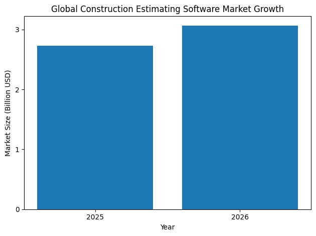
By 2026, the global construction estimating software market has grown into a multi-billion-dollar industry, reflecting the widespread adoption of digital tools across the sector. Governments and private developers are investing heavily in infrastructure development, including transportation networks, renewable energy facilities, and urban expansion projects. These initiatives require advanced construction technologies capable of managing large-scale earthwork operations and complex project logistics.
Within this evolving digital landscape, a number of earthwork estimating software platforms have emerged as industry leaders. These solutions differ in their technical capabilities, pricing models, and target users, but they all share a common objective: improving the accuracy, efficiency, and reliability of construction estimation. Some platforms focus on heavy civil infrastructure projects, offering sophisticated terrain modeling and mass haul analysis tools. Others emphasize flexibility and usability, providing intuitive interfaces that allow contractors to perform fast quantity takeoffs from construction drawings.
The top earthwork estimating software platforms in 2026 include solutions developed by some of the most influential companies in construction technology. These tools are widely used by contractors, engineers, and surveyors around the world to manage excavation planning, analyze digital terrain models, and generate detailed cost estimates. Their advanced features enable construction professionals to visualize project sites in three dimensions, compare alternative grading strategies, and optimize earthmoving operations before work even begins.
Another key advantage of modern earthwork estimating software is its ability to integrate with other digital construction systems. Many platforms now connect directly with surveying equipment, drone mapping technologies, and machine control systems used by earthmoving equipment. This integration ensures that digital design models created during the estimation phase can be transferred directly to field machinery, allowing operators to execute grading plans with high precision. As a result, contractors can maintain consistency between design specifications and actual site operations.
In addition to improving operational efficiency, digital estimation tools also help construction firms remain competitive in a highly demanding market environment. Infrastructure projects often involve tight bidding deadlines and narrow profit margins. Contractors must prepare accurate estimates quickly to secure contracts while ensuring that costs are carefully controlled. Earthwork estimating software enables companies to respond faster to bidding opportunities while reducing the risk of underestimating project expenses.
Another factor contributing to the growing importance of estimating software is the increasing emphasis on data-driven decision-making within the construction industry. Digital tools allow contractors to analyze historical project data, monitor performance metrics, and identify patterns that influence cost and productivity. By leveraging these insights, construction firms can improve future estimates, optimize resource allocation, and enhance overall project outcomes.
As the construction sector continues to modernize, the role of estimators is also evolving. Instead of focusing primarily on manual measurements and calculations, estimators are becoming strategic analysts who interpret digital data and evaluate project scenarios. Advanced software platforms provide powerful visualization tools that help estimators and project managers understand terrain conditions, excavation requirements, and potential construction challenges before work begins.
In this comprehensive guide to the top 10 earthwork estimating software in the world in 2026, readers will explore the most advanced tools currently shaping the construction technology landscape. Each platform offers unique features designed to address specific aspects of earthwork estimation, from automated takeoffs and digital terrain modeling to integrated cost databases and cloud-based collaboration.
Understanding the strengths and capabilities of these leading solutions is essential for construction professionals seeking to improve project efficiency, reduce estimation errors, and remain competitive in a rapidly evolving industry. As digital transformation continues to redefine how construction projects are planned and executed, earthwork estimating software will remain a cornerstone technology for contractors and engineers working on the infrastructure projects that shape the modern world.
Before we venture further into this article, we would like to share who we are and what we do.
About 9cv9
9cv9 is a business tech startup based in Singapore and Asia, with a strong presence all over the world.
With over nine years of startup and business experience, and being highly involved in connecting with thousands of companies and startups, the 9cv9 team has listed some important learning points in this overview of the Top 10 Earthwork Estimating Software To Know in 2026.
If you like to get your company listed in our top B2B software reviews, check out our world-class 9cv9 Media and PR service and pricing plans here.
Top 10 Earthwork Estimating Software To Know in 2026
- AGTEK Gradework
- HCSS HeavyBid
- InSite Elevation Pro
- Trimble Business Center (TBC)
- Carlson Takeoff Suite
- B2W Estimate
- MudShark
- Kubla Cubed
- PlanSwift (by ConstructConnect)
- STACK
1. AGTEK Gradework
Within the global construction technology ecosystem of 2026, AGTEK Gradework continues to be recognized as one of the most advanced platforms designed specifically for heavy civil construction and earthmoving operations. As large infrastructure projects become increasingly complex, contractors require software solutions capable of integrating digital design models, terrain data, and field machinery operations into a single coordinated workflow.
AGTEK Gradework has built its reputation by addressing these needs through highly accurate earthwork modeling, advanced grading simulations, and full compatibility with modern machine control systems. The platform is widely used by contractors working on highway construction, airport runways, mining operations, land development, and other large-scale excavation projects where accurate material estimation and efficient hauling strategies are essential.
Unlike traditional estimating tools that focus only on quantity takeoffs, AGTEK Gradework provides a fully integrated modeling environment. The system allows estimators and engineers to visualize site conditions in three dimensions, simulate grading plans, and calculate volumes with a high level of accuracy. In 2026, the software remains one of the most trusted platforms for organizations seeking to reduce estimation errors, improve bidding accuracy, and streamline earthmoving operations.
Position of AGTEK Gradework Among Leading Earthwork Estimating Platforms
The earthwork estimating software market has grown rapidly over the past decade as digital construction technologies have matured. Leading platforms now combine 3D modeling, drone mapping, machine control integration, and construction scheduling into unified solutions.
Within this competitive environment, AGTEK Gradework continues to rank among the most powerful solutions used by heavy civil contractors.
| Software Platform | Primary Industry Focus | Core Strength in Earthwork Estimation |
|---|---|---|
| AGTEK Gradework | Heavy civil and infrastructure | Advanced 3D modeling and machine control support |
| Trimble Business Center | Surveying and construction planning | Survey data processing and field integration |
| Carlson Takeoff | Earthwork takeoffs and mapping | Cost-effective volume calculation tools |
| HCSS HeavyBid | Construction bidding and estimating | Integrated cost estimation workflows |
| Kubla Cubed | Civil engineering earthworks | Flexible 3D terrain modeling |
| InSite Elevation Pro | Mass excavation projects | Large-scale volume and surface calculations |
| Viewpoint Estimating | Construction financial planning | Bid management and cost control |
| CostX | Quantity surveying | BIM-integrated quantity takeoffs |
| MudShark | Utility construction and excavation | GPS-driven site modeling |
| Trimble WorksManager | Machine control coordination | Field execution and equipment integration |
AGTEK Gradework stands out because of its ability to combine design modeling, estimation, and field execution into a unified workflow. This capability significantly reduces discrepancies between office-based estimates and on-site construction performance.
AGTEK’s Integrated “Dirt Simple” Construction Technology Ecosystem
AGTEK has built its technology philosophy around what it calls the “Dirt Simple” ecosystem. This concept refers to a suite of interconnected tools designed to simplify earthwork planning, estimation, and construction management.
The ecosystem provides contractors with tools that span the entire lifecycle of a project, from early-stage bidding to project completion.
| Project Lifecycle Phase | AGTEK Functional Module | Operational Benefit for Contractors |
|---|---|---|
| Pre-Bid Planning | Gradework Modeling | Accurate terrain modeling and design comparison |
| Estimating | Volume Calculation Tools | Precise cut-and-fill analysis for bidding |
| Construction Planning | 4D Simulation Engine | Scenario modeling for haul efficiency |
| Field Deployment | Machine Control Models | Direct integration with grading equipment |
| Progress Monitoring | Production Tracking | Real-time project progress visibility |
| Project Closeout | Final Volume Reporting | Accurate material reconciliation |
This integrated approach allows contractors to transition seamlessly between planning, estimating, and field execution stages without losing data consistency.
Advanced 4D Modeling and Scenario Simulation
One of the most advanced capabilities of AGTEK Gradework in 2026 is its 4D modeling system. In construction technology terminology, 4D modeling refers to the integration of three-dimensional spatial modeling with time-based construction sequencing.
Through this functionality, contractors can simulate the progression of excavation and grading work across different project phases. This allows stakeholders to analyze multiple construction scenarios before committing to a specific operational strategy.
| Simulation Parameter | Purpose in Earthwork Planning | Operational Impact |
|---|---|---|
| Haul Route Optimization | Calculates efficient material transport routes | Reduced fuel costs and equipment wear |
| Phase-Based Excavation | Divides projects into logical construction stages | Improved resource allocation |
| Equipment Productivity | Estimates output of machinery fleets | Accurate scheduling and staffing |
| Material Redistribution | Simulates movement of cut and fill materials | Reduced need for imported fill |
| Construction Sequencing | Models project timelines visually | Improved coordination among teams |
The ability to compare multiple grading designs with a single command allows contractors to identify the most cost-effective approach before construction begins.
Multi-Source Data Integration and Terrain Modeling
Modern earthwork estimating software must handle a wide range of digital data inputs. AGTEK Gradework is designed to process multiple file formats and surveying technologies, allowing engineers to create highly accurate terrain models.
This capability ensures that estimates are based on reliable site conditions rather than assumptions or incomplete survey data.
| Data Input Source | Application in Earthwork Estimation | Technical Benefit |
|---|---|---|
| CAD Design Files | Imports engineering drawings and grading plans | Maintains design accuracy |
| PDF Construction Plans | Extracts measurements from plan sheets | Simplifies plan interpretation |
| Drone Survey Imagery | Generates aerial terrain mapping | Improves site visibility |
| GIS Mapping Data | Provides geospatial context for large projects | Enhances regional analysis |
| LiDAR Point Clouds | Produces detailed surface models | Extremely high terrain precision |
| Traditional Survey Data | Validates elevation points and benchmarks | Ensures real-world accuracy |
The ability to combine these datasets into a single digital model significantly reduces errors that often occur during manual earthwork calculations.
Machine Control Compatibility and Field Integration
A key advantage of AGTEK Gradework is its seamless compatibility with major machine control systems used by construction equipment manufacturers. Machine control technology allows bulldozers, graders, and excavators to follow digital grading models with high precision using GPS and positioning systems.
AGTEK-generated models can be exported directly to commonly used machine control platforms.
| Machine Control Provider | Equipment Types Supported | Integration Benefit |
|---|---|---|
| Leica Geosystems | Excavators, graders, bulldozers | High-precision grade control |
| Topcon | Earthmoving machinery fleets | Seamless design-to-field transfer |
| Trimble | GPS-guided construction equipment | Accurate grading execution |
This interoperability ensures that the designs produced in the office environment are executed in the field with minimal deviation, improving project accuracy and reducing rework.
Pricing Structure and Licensing Options in 2026
AGTEK Gradework is considered a premium earthwork estimating solution, and its pricing structure reflects the advanced capabilities and specialized industry focus of the platform.
| Pricing Component | Typical 2026 Pricing Range | Description |
|---|---|---|
| Starting Subscription | $650 per user per month | Annual subscription plan |
| Perpetual License | $15,000 – $25,000 per seat | One-time license purchase |
| Annual Maintenance | 15% – 20% of license cost | Software updates and support |
| Training Sessions | $500 per session | Recommended onboarding training |
| Mobile Access | Included | Cloud-enabled field accessibility |
Although the platform requires a significant financial investment, many contractors report that the productivity gains and reduction in estimation errors quickly offset the initial costs.
User Satisfaction and Market Sentiment
Industry feedback for AGTEK Gradework remains highly positive in 2026. Contractors frequently highlight the platform’s accuracy, modeling capabilities, and efficiency improvements when compared to older estimation methods.
| Evaluation Category | User Feedback Summary |
|---|---|
| Overall Rating | 4.8 out of 5 based on 53 verified reviews |
| Estimation Accuracy | Widely praised for precise volume calculations |
| Ease of Learning | Moderate learning curve for new users |
| Software Performance | Highly stable for large project models |
| Cost Perception | Considered expensive for small contractors |
Many users report that AGTEK Gradework delivers some of the fastest return-on-investment timelines among construction technology platforms. Time savings during takeoffs, improved bid accuracy, and reduced project rework are frequently cited as the key drivers behind its strong industry reputation.
Conclusion: AGTEK Gradework’s Role in Modern Earthwork Estimation
As construction projects grow larger and more technically demanding, digital estimation tools have become indispensable for contractors seeking to maintain competitive advantage. AGTEK Gradework continues to stand at the forefront of this technological shift, offering a comprehensive platform that integrates modeling, estimation, machine control, and project simulation.
By combining precise terrain analysis, advanced 4D modeling capabilities, and seamless integration with field machinery, AGTEK Gradework provides contractors with the tools needed to plan and execute earthmoving operations with unprecedented accuracy.
For heavy civil construction companies operating in the global infrastructure market of 2026, the platform remains one of the most reliable and sophisticated earthwork estimating solutions available.
2. HCSS HeavyBid
HCSS HeavyBid has established itself as one of the most influential estimating platforms within the heavy civil construction industry. By 2026, the software is widely recognized as a specialized solution for contractors involved in large-scale infrastructure projects, particularly those working on government-funded transportation systems, public utilities, and complex multi-phase construction developments.
Developed by HCSS (Heavy Construction Systems Specialists), the platform has become a cornerstone for contractors who require highly detailed cost analysis, crew-based estimating, and structured bidding workflows. In sectors where infrastructure projects can reach budgets in the hundreds of millions or even billions of dollars, accuracy in estimating and bid preparation becomes critical. HeavyBid addresses these needs by offering deep cost analysis capabilities and detailed production modeling.
The software is particularly prominent among contractors working with Departments of Transportation (DOT), where regulatory compliance, detailed cost structures, and transparent bid documentation are mandatory requirements. Because of its strong alignment with these demands, HeavyBid has earned a reputation as one of the most comprehensive estimating solutions for infrastructure contractors worldwide.
Industry Position of HCSS HeavyBid Among Top Earthwork Estimating Platforms
Within the competitive landscape of construction estimating software in 2026, HCSS HeavyBid occupies a unique position. Unlike platforms that primarily focus on terrain modeling or volume calculations, HeavyBid is engineered around cost analysis, crew productivity modeling, and bid management for large infrastructure projects.
| Software Platform | Primary Construction Segment | Core Estimating Strength |
|---|---|---|
| HCSS HeavyBid | Infrastructure and DOT projects | Crew-based estimating and historical cost data |
| AGTEK Gradework | Earthmoving and grading | 3D terrain modeling and volume calculation |
| Trimble Business Center | Surveying and site modeling | Survey integration and field data processing |
| Kubla Cubed | Civil engineering earthworks | Flexible terrain and cut-fill analysis |
| Carlson Takeoff | Earthwork quantity estimation | Efficient takeoff calculations |
| InSite Elevation Pro | Mass excavation and site preparation | Surface modeling and volume computation |
| CostX | Quantity surveying | BIM-based quantity takeoffs |
| Viewpoint Estimating | Construction financial planning | Budgeting and project cost management |
| MudShark | Utility construction projects | GPS-enabled site modeling |
| Trimble WorksManager | Machine control coordination | Equipment integration and field execution |
HeavyBid distinguishes itself by focusing on the financial and operational side of construction bidding, rather than purely geometric earthwork modeling.
Core Strength: Crew-Based Estimating Methodology
One of the defining features of HCSS HeavyBid is its crew-based estimating model. This approach allows contractors to estimate costs based on real-world crew productivity rather than relying solely on static material or equipment rates.
The system enables estimators to build cost structures around labor teams, machinery fleets, and production rates. By modeling the output of actual construction crews, the software can generate more accurate bid proposals and operational forecasts.
| Estimating Component | Function within HeavyBid | Strategic Benefit for Contractors |
|---|---|---|
| Crew Production Modeling | Calculates output rates for construction crews | More realistic cost forecasting |
| Equipment Cost Tracking | Estimates operational costs of heavy machinery | Improved equipment utilization |
| Labor Cost Analysis | Calculates workforce costs per production unit | Accurate labor budgeting |
| Material Cost Integration | Tracks supply costs for construction materials | Transparent project costing |
| Subcontractor Pricing | Incorporates third-party contractor costs | Comprehensive bid preparation |
By combining these factors into a single estimating framework, contractors gain a clearer understanding of the real production costs associated with large infrastructure projects.
Advanced Job Costing and Historical Cost Analysis
Another key strength of HeavyBid lies in its historical cost database. The software stores cost data from previous projects and allows estimators to analyze trends in productivity, equipment performance, and labor costs.
This historical insight allows construction firms to improve the accuracy of future bids by referencing real-world project outcomes.
| Data Analysis Capability | Application in Construction Estimating | Operational Advantage |
|---|---|---|
| Historical Cost Database | Stores previous project cost structures | Improved bid accuracy |
| Production Rate Analysis | Compares past crew performance metrics | More reliable forecasting |
| Cost Trend Monitoring | Identifies fluctuations in labor or materials | Better financial planning |
| Risk Factor Modeling | Evaluates uncertainty in project estimates | Reduced financial exposure |
| Benchmark Comparison | Compares performance across multiple projects | Continuous operational improvement |
For large contractors managing dozens or hundreds of infrastructure projects, these analytical capabilities become essential tools for maintaining competitive and profitable bidding strategies.
Cloud-Based Collaboration and Workflow Integration
The 2026 edition of HCSS HeavyBid places strong emphasis on cloud-based architecture and collaborative workflows. Construction estimating teams are often distributed across multiple offices and project locations. As a result, real-time data sharing and centralized project management have become critical features in modern estimating platforms.
HeavyBid’s cloud-enabled infrastructure allows teams to collaborate on bid preparation simultaneously while maintaining centralized control over cost data and project documentation.
| Collaboration Feature | Functional Description | Operational Impact |
|---|---|---|
| Real-Time Data Updates | Instant synchronization across user accounts | Improved team coordination |
| Multi-User Bid Editing | Allows multiple estimators to work on a bid | Faster bid preparation |
| Centralized Data Storage | Stores project data in cloud infrastructure | Improved security and accessibility |
| Version Control Tracking | Maintains record of bid revisions | Transparent audit trails |
| Remote Access Capability | Enables access from different project offices | Flexible workflow management |
This collaborative framework is particularly valuable for contractors preparing bids for large infrastructure tenders where teams of estimators, engineers, and project managers must work together under strict deadlines.
Integration with the HCSS Construction Technology Ecosystem
HCSS HeavyBid is not designed as a standalone application but rather as the central estimating component of a broader construction management ecosystem. The software integrates with several other HCSS platforms that handle field operations, equipment management, and project monitoring.
These integrations allow companies to connect their estimating processes directly with field performance data.
| HCSS Platform | Primary Function | Integration Benefit |
|---|---|---|
| HeavyBid | Project estimating and bidding | Central cost modeling engine |
| HeavyJob | Field productivity tracking | Real-time construction data |
| Equipment360 | Equipment fleet management | Machine cost monitoring |
| Telematics Integration | Equipment performance tracking | Data-driven equipment utilization |
| Safety Management Tools | Construction safety compliance tracking | Risk mitigation and regulatory compliance |
This integrated ecosystem allows contractors to move seamlessly from estimation to project execution while maintaining consistent cost tracking throughout the project lifecycle.
Market Metrics and Industry Adoption in 2026
By 2026, HCSS HeavyBid has achieved widespread adoption among infrastructure contractors across North America and other global markets. Its strong presence in DOT-related construction projects has solidified its position as one of the most trusted estimating solutions for government-funded infrastructure development.
| Industry Metric | Value or Detail |
|---|---|
| Primary Market Segment | Large infrastructure and heavy civil projects |
| Pricing Model | Custom pricing based on company size and needs |
| Active User Base | More than 50,000 professional users |
| G2 User Rating | 4.6 out of 5 based on 224 reviews |
| Capterra User Rating | 4.6 out of 5 based on 506 reviews |
| Typical Learning Curve | Approximately 1 to 3 months for proficiency |
These adoption metrics demonstrate the platform’s strong reputation within the heavy construction industry.
User Experience and Industry Feedback
Despite its powerful capabilities, HCSS HeavyBid is often described by users as a complex system that requires time to master. The software contains a large number of features designed for handling intricate bid structures, which can initially feel overwhelming for new users.
However, experienced estimators frequently emphasize that the platform’s complexity is also the source of its strength.
| User Feedback Category | Summary of Industry Sentiment |
|---|---|
| Estimating Depth | Extremely detailed and powerful cost analysis |
| Interface Complexity | Dense interface with steep learning curve |
| Bid Structure Management | Excellent support for multi-phase projects |
| Infrastructure Projects | Highly optimized for DOT and public works |
| Return on Investment | Strong long-term value for large contractors |
Many contractors consider HeavyBid to be a “powerhouse” estimating system capable of handling some of the most complex bid structures in the construction industry.
Conclusion: HCSS HeavyBid’s Strategic Importance for Infrastructure Contractors
In the evolving construction technology ecosystem of 2026, HCSS HeavyBid continues to play a critical role for contractors engaged in large-scale infrastructure development. Its deep crew-based estimating framework, extensive historical cost analysis tools, and integration with field management platforms make it one of the most comprehensive estimating solutions available.
While the platform requires a significant investment in training and implementation, many large construction firms consider it indispensable for managing the financial complexity of highway construction, pipeline installation, and major utility infrastructure projects.
For organizations operating in high-value civil construction markets, HCSS HeavyBid remains one of the most trusted and widely adopted software solutions for accurate, data-driven construction bidding.
3. InSite Elevation Pro
InSite Elevation Pro has emerged as one of the most widely adopted earthwork estimating solutions for contractors involved in site preparation, excavation, and utility infrastructure projects. By 2026, the platform has secured a strong position among mid-sized construction firms seeking fast, reliable, and visually intuitive tools for calculating earthwork quantities and preparing project estimates.
As construction schedules continue to tighten and project complexity increases, many contractors require estimating software capable of delivering accurate takeoffs within short timeframes. InSite Elevation Pro has gained industry recognition for its speed and usability, particularly in environments where rapid bid preparation and precision measurements are essential.
The software specializes in converting PDF drawings and CAD plans into highly accurate terrain models, allowing estimators to quickly calculate cut and fill volumes, analyze underground utility networks, and visualize site conditions in three-dimensional environments. With an accuracy rate reported between 98 percent and 99 percent on standard structural and architectural plans, the platform is considered a dependable tool for contractors seeking to reduce estimation errors while maintaining high productivity.
Position of InSite Elevation Pro Among Leading Earthwork Estimating Platforms
Within the global construction technology ecosystem, InSite Elevation Pro occupies a strategic position between high-end enterprise modeling platforms and entry-level takeoff software. Its balance of speed, visualization capabilities, and affordability has made it especially popular among mid-sized contractors.
| Software Platform | Primary Construction Segment | Key Functional Strength |
|---|---|---|
| InSite Elevation Pro | Sitework and utility construction | Rapid PDF and CAD takeoffs with 3D visualization |
| AGTEK Gradework | Heavy civil earthmoving projects | Advanced 3D terrain modeling and machine control |
| HCSS HeavyBid | Infrastructure bidding and estimating | Crew-based cost analysis and bid management |
| Carlson Takeoff | Civil engineering takeoffs | Efficient earthwork quantity calculations |
| Kubla Cubed | Engineering earthworks modeling | Flexible terrain design and cut-fill analysis |
| Trimble Business Center | Survey data processing | Integration with survey equipment and field systems |
| CostX | Quantity surveying and BIM analysis | Building information modeling integration |
The software’s reputation for fast calculations and straightforward interface has made it particularly valuable for contractors who need to produce accurate estimates under tight bidding deadlines.
Rapid PDF and CAD Takeoff Capabilities
One of the defining strengths of InSite Elevation Pro is its ability to perform extremely fast takeoffs from PDF and CAD files. In many construction firms, estimators must work with large volumes of design documents that include grading plans, utility layouts, and structural site drawings.
Elevation Pro converts these documents into measurable digital models that allow users to calculate earthwork volumes and analyze terrain conditions within minutes.
| Takeoff Capability | Functional Description | Practical Benefit for Estimators |
|---|---|---|
| PDF Plan Extraction | Converts plan sheets into measurable models | Rapid quantity takeoffs |
| CAD Drawing Integration | Imports digital design files | Maintains engineering accuracy |
| Automated Volume Analysis | Calculates cut and fill quantities automatically | Reduced manual calculation time |
| Material Quantity Estimation | Measures soil, gravel, and structural materials | Accurate cost forecasting |
| Underground Utility Mapping | Identifies and measures subsurface utilities | Improved infrastructure planning |
These capabilities enable estimators to move quickly from plan analysis to quantity calculations, helping construction companies meet increasingly competitive bid timelines.
Advanced Visualization and 3D Modeling Features
In addition to rapid takeoff capabilities, InSite Elevation Pro offers a suite of visualization tools that allow project teams to better understand terrain conditions and construction progress.
The software provides interactive 3D modeling environments that allow estimators, engineers, and project managers to visualize grading plans, excavation depths, and material distribution across the job site.
| Visualization Feature | Purpose in Construction Planning | Operational Advantage |
|---|---|---|
| 3D Terrain Modeling | Displays surface elevations and contours | Improved site understanding |
| Elevation Heat Maps | Color-coded mapping of terrain elevation | Quick identification of grading areas |
| Cut and Fill Visualization | Graphical representation of excavation zones | Clear planning of earthmoving operations |
| 4D Walk-Through Simulation | Simulates project progress over time | Enhanced project coordination |
| Interactive Site Navigation | Allows users to explore digital terrain models | Improved communication among teams |
These visualization features help project stakeholders quickly interpret complex terrain data and make more informed decisions about grading strategies and excavation methods.
Core Earthwork Calculation Capabilities
At the center of InSite Elevation Pro’s functionality is its ability to calculate earthwork volumes and material quantities with high levels of accuracy. The software uses digital terrain modeling techniques to compare existing site conditions with proposed grading plans.
This comparison enables the system to determine how much material must be excavated, relocated, or imported to complete the project.
| Calculation Function | Description of Analytical Process | Value for Contractors |
|---|---|---|
| Cut Volume Calculation | Measures soil or rock to be removed | Accurate excavation planning |
| Fill Volume Calculation | Determines material needed to raise elevations | Efficient material allocation |
| Surface Comparison Analysis | Compares existing and proposed terrain models | Precise earthwork estimation |
| Utility Trench Analysis | Calculates excavation volumes for pipelines | Improved underground construction planning |
| Material Redistribution | Models movement of soil across the project site | Reduced hauling costs |
With these tools, contractors can generate accurate bid estimates while minimizing the risk of material shortages or unexpected excavation costs.
Industry Adoption and User Demographics
By 2026, InSite Elevation Pro has gained a strong user base among construction professionals across multiple disciplines. Although its primary adoption is within sitework and excavation contractors, the platform also sees use among civil engineers and utility infrastructure specialists.
| Industry Segment | Percentage of User Base (2026) |
|---|---|
| Construction Contractors | 90% |
| Civil Engineering Firms | 5% |
| Utility Infrastructure | 3% |
| Other Industries | 2% |
This distribution highlights the software’s strong alignment with construction professionals who require fast and accurate earthwork calculations during the project planning and bidding phases.
Pricing Model and Subscription Structure
InSite Elevation Pro offers a relatively straightforward pricing structure compared to many enterprise-level construction technology platforms. The software operates primarily on a subscription model, making it accessible to mid-sized companies that may not have the budgets required for high-end enterprise software.
| Pricing Component | 2026 Subscription Detail |
|---|---|
| Basic Subscription Plan | $3,900 per year |
| Free Trial Availability | Free trial and limited free version |
| Technical Support | Seven-day phone and email support |
| Integration Capability | No public API available in 2026 |
The inclusion of a free trial option allows potential users to evaluate the platform before committing to a subscription, which has contributed to its steady adoption within the construction industry.
User Feedback and Performance Ratings
InSite Elevation Pro consistently receives strong user ratings across construction technology review platforms. Contractors frequently highlight the software’s speed, accuracy, and intuitive interface as key advantages.
| Performance Category | Average User Rating |
|---|---|
| Overall User Satisfaction | 4.8 out of 5 stars |
| Cut and Fill Estimation | 4.89 rating |
| Ease of Learning | 4.75 rating |
| Visualization Tools | 4.70 rating |
| Customizable Templates | 3.95 rating |
While the platform excels in volume calculations and visualization, some users report that its template customization features are slightly less flexible compared to competing software solutions.
Conclusion: The Strategic Role of InSite Elevation Pro in Earthwork Estimation
As construction projects become increasingly data-driven, earthwork estimating software has become an indispensable tool for contractors seeking both efficiency and accuracy. InSite Elevation Pro has positioned itself as a highly practical solution for professionals who need rapid takeoffs, clear visualization, and dependable volume calculations.
Its ability to process PDF and CAD plans quickly, generate highly accurate cut-and-fill estimates, and provide intuitive visual representations of project terrain has made it a valuable asset for sitework contractors and utility construction firms.
In the broader landscape of earthwork estimating technology in 2026, InSite Elevation Pro stands out as a balanced solution that combines performance, usability, and affordability, making it particularly attractive to mid-sized construction companies working in competitive project environments.
4. Trimble Business Center (TBC)
Trimble Business Center (TBC) occupies a critical role in the modern construction technology landscape by serving as the technical connection between surveying operations and heavy civil construction workflows. In 2026, the platform continues to be widely used by contractors, surveyors, and civil engineers who require advanced tools for terrain modeling, earthwork volume analysis, and machine control data preparation.
Unlike traditional earthwork estimating software that focuses primarily on cost estimation or bid preparation, Trimble Business Center is designed to process survey-grade data and convert it into actionable construction models. The platform enables professionals to transform raw field data collected through drones, GPS survey instruments, and LiDAR scanning into detailed digital terrain models that can be used for site analysis, project planning, and machine control systems.
As infrastructure projects increasingly rely on digital construction workflows, Trimble Business Center has become an essential component within the broader Trimble construction ecosystem. The software allows companies to connect survey data, office-based modeling, and on-site construction equipment into a unified operational framework.
Industry Position of Trimble Business Center Among Earthwork Estimating Platforms
Within the global earthwork estimating software market in 2026, Trimble Business Center is positioned as a technical and analytical platform rather than a traditional bidding or estimating tool. Its primary focus lies in survey data processing, terrain modeling, and construction design preparation.
| Software Platform | Core Construction Role | Primary Technical Capability |
|---|---|---|
| Trimble Business Center | Survey processing and site modeling | Survey data integration and terrain analysis |
| AGTEK Gradework | Heavy civil earthwork estimation | Advanced 3D grading and volume calculations |
| HCSS HeavyBid | Infrastructure bid management | Crew-based estimating and cost forecasting |
| InSite Elevation Pro | Sitework quantity estimation | Fast PDF and CAD takeoffs |
| Kubla Cubed | Civil engineering terrain modeling | Flexible earthwork design modeling |
| Carlson Takeoff | Civil earthwork takeoffs | Efficient cut and fill calculations |
| CostX | Quantity surveying and BIM analysis | Building information modeling integration |
This positioning allows Trimble Business Center to function as a foundational data-processing platform that supports both engineering design and construction operations.
Purpose and Capabilities of the Construction Edition of Trimble Business Center
The Construction edition of Trimble Business Center is specifically designed for professionals working in earthmoving, site preparation, and civil infrastructure development. This edition includes specialized tools that allow contractors to generate digital terrain models, prepare machine control files, and perform mass haul analysis.
The platform is frequently used during early project planning phases, where survey data must be converted into accurate digital models before construction activities begin.
| Construction Workflow Stage | Trimble Business Center Function | Operational Benefit |
|---|---|---|
| Survey Data Import | Imports GPS, total station, and drone data | Accurate terrain modeling |
| Terrain Surface Creation | Generates digital terrain models | Detailed site visualization |
| Quantity Takeoff Reporting | Calculates cut and fill volumes | Accurate earthwork estimation |
| Machine Control Model Creation | Produces design files for grading equipment | Seamless field execution |
| Mass Haul Analysis | Simulates earthmoving logistics | Optimized material movement |
By enabling these capabilities, Trimble Business Center allows contractors to bridge the gap between survey data and operational earthmoving strategies.
Advanced Data Processing and Terrain Modeling
One of the most significant strengths of Trimble Business Center lies in its ability to process extremely large datasets with high precision. Modern construction projects often involve complex terrain conditions that require highly detailed data collection methods.
The platform supports multiple forms of digital surveying data, including drone imagery and LiDAR-based point clouds.
| Data Type Processed | Source of Data Collection | Analytical Purpose |
|---|---|---|
| GPS Survey Points | Field survey instruments | Terrain elevation measurement |
| Total Station Measurements | On-site surveying equipment | Precise coordinate mapping |
| Drone Photogrammetry | Aerial drone surveys | Large-scale site mapping |
| LiDAR Point Clouds | Laser scanning systems | High-density terrain modeling |
| CAD Design Files | Engineering design software | Integration with construction plans |
Once processed, these datasets are converted into digital terrain models that can be used for earthwork planning, grading simulations, and construction layout.
Mass Haul Analysis and Earthmoving Optimization
Mass haul analysis is a key component of earthwork planning for large construction projects. This analysis determines how excavated materials should be transported across a construction site to minimize hauling distances and equipment costs.
Trimble Business Center includes specialized tools that allow contractors to simulate earthmoving logistics and optimize excavation strategies.
| Mass Haul Analysis Feature | Description of Function | Strategic Advantage |
|---|---|---|
| Material Movement Mapping | Tracks movement of excavated soil | Reduced transport distances |
| Haul Route Optimization | Calculates efficient hauling paths | Lower fuel consumption |
| Cut and Fill Balance | Matches excavation zones with fill areas | Reduced import/export of soil |
| Earthwork Volume Tracking | Monitors material quantities across phases | Accurate project control |
| Construction Sequencing | Aligns earthmoving activities with schedules | Improved operational planning |
These capabilities are particularly valuable for large-scale infrastructure projects such as highway construction, airport development, and mining operations.
Integration with Trimble Machine Control and WorksManager
One of the most distinctive advantages of Trimble Business Center is its deep integration with Trimble’s machine control systems and cloud-based construction management tools. This integration allows contractors to transfer design models directly from the office to construction equipment operating in the field.
The WorksManager platform plays a key role in this process by providing remote connectivity between office systems and on-site machinery.
| Trimble Platform | Primary Function | Integration Benefit |
|---|---|---|
| Trimble Business Center | Survey data processing and modeling | Creation of digital construction models |
| WorksManager | Cloud-based design distribution | Remote file transfer to field equipment |
| Trimble Machine Control | GPS-guided construction machinery | Precise grading and excavation |
| Field Device Monitoring | Equipment status tracking | Remote troubleshooting |
| Design Revision Management | Updates machine control models | Continuous field accuracy |
This level of integration allows contractors to maintain consistent data across design offices, survey teams, and construction equipment.
Trimble Business Center 2026 Pricing Structure
In 2026, Trimble introduced a revised pricing model designed to encourage adoption among both small contractors and large enterprise construction firms. The new tiered subscription structure offers increasing discounts as the number of licensed users grows.
| Number of Seats Licensed | Discount Applied | Pricing Benefit for Organizations |
|---|---|---|
| 1 Seat | 0 percent | Standard subscription price |
| 2–5 Seats | 40 percent | Small team adoption incentive |
| 6–9 Seats | 50 percent | Medium-sized contractor discount |
| 10–99 Seats | 65 percent | Corporate scaling advantage |
| 100+ Seats | 80 percent | Enterprise-level pricing |
The starter-tier subscription price for Trimble Business Center begins at approximately $922 per user per year, making it relatively affordable compared to many enterprise construction modeling platforms.
Learning Curve and User Experience
While Trimble Business Center is widely praised for its technical capabilities, users frequently report that the platform has a steep learning curve. The software contains a large number of specialized tools designed for surveying professionals and experienced construction engineers.
This complexity can initially challenge new users, but it also allows the software to perform highly advanced terrain analysis and quality control tasks.
| User Experience Category | Industry Feedback Summary |
|---|---|
| Interface Complexity | Feature-rich but complex interface |
| Learning Curve | Moderate to steep training period |
| Survey Data Processing | Highly accurate and reliable |
| Terrain Modeling | Excellent precision in surface creation |
| Quality Control Tools | Strong validation for survey data |
Because of its powerful survey processing capabilities, Trimble Business Center is widely considered indispensable for professional surveyors and construction engineers responsible for maintaining site accuracy.
Conclusion: Trimble Business Center’s Strategic Role in Digital Construction
As construction projects increasingly rely on digital terrain modeling and machine-controlled equipment, the importance of accurate survey data processing continues to grow. Trimble Business Center has positioned itself as a central platform for transforming raw survey data into actionable construction models.
By combining advanced data processing capabilities, mass haul analysis tools, and direct integration with Trimble’s machine control systems, the platform enables contractors to move seamlessly from surveying to construction execution.
In the global construction technology landscape of 2026, Trimble Business Center remains one of the most influential platforms for companies seeking precise terrain analysis, reliable earthwork calculations, and efficient integration between office-based design teams and field construction equipment.
5. Carlson Takeoff Suite
Carlson Takeoff Suite is widely recognized as a powerful CAD-based earthwork estimating and construction takeoff platform used by civil engineers, surveyors, and construction contractors. By 2026, the software has maintained a strong presence in the earthwork estimating market due to its deep integration with CAD environments and its advanced capabilities for terrain modeling, mass haul analysis, and quantity calculations.
Developed by Carlson Software, the platform is built upon either IntelliCAD 13.1 or AutoCAD OEM technology. This CAD foundation allows the software to integrate seamlessly with engineering design workflows, making it particularly attractive to professionals who rely heavily on CAD drawings for construction planning and project documentation.
Carlson Takeoff is frequently used in civil engineering, land development, highway construction, mining operations, and site preparation projects. Its ability to convert digital drawings and scanned construction plans into highly accurate terrain models makes it an essential tool for calculating earthwork quantities and optimizing excavation strategies.
Position of Carlson Takeoff Among Leading Earthwork Estimating Platforms
Within the global construction technology ecosystem, Carlson Takeoff occupies a unique position as a highly technical CAD-based solution. While many modern earthwork platforms emphasize cloud-based workflows and automated visualization, Carlson Takeoff focuses on precision, engineering-level analysis, and integration with advanced surveying tools.
| Software Platform | Core Industry Segment | Primary Technical Strength |
|---|---|---|
| Carlson Takeoff Suite | Civil engineering and surveying | CAD-based earthwork modeling and takeoff analysis |
| AGTEK Gradework | Heavy civil earthmoving | Advanced 3D grading and machine control modeling |
| Trimble Business Center | Survey data processing | Terrain modeling and machine control integration |
| HCSS HeavyBid | Infrastructure project bidding | Crew-based estimating and cost analysis |
| InSite Elevation Pro | Sitework and utility estimation | Rapid PDF and CAD takeoffs |
| Kubla Cubed | Civil engineering earthworks | Flexible terrain modeling |
| CostX | Quantity surveying | BIM-integrated takeoffs |
This positioning allows Carlson Takeoff to serve professionals who require a CAD-native environment for precise terrain calculations and engineering analysis.
CAD-Based Architecture and Technical Workflow
One of the defining features of Carlson Takeoff is its fully integrated CAD environment. Unlike some estimating tools that import drawings solely for measurement purposes, Carlson Takeoff allows engineers and estimators to interact directly with CAD models, making it possible to refine designs, correct linework, and perform advanced terrain analysis.
This CAD integration ensures that earthwork estimates remain closely aligned with engineering drawings and site design plans.
| CAD Workflow Feature | Technical Function | Operational Benefit |
|---|---|---|
| Native CAD Editing | Enables modification of design drawings | Maintains design accuracy |
| Surface Modeling | Creates terrain models from contour lines | Precise earthwork calculations |
| Breakline Analysis | Defines terrain edges and structural boundaries | Accurate surface representation |
| Road Network Management | Organizes road corridor data | Improved infrastructure planning |
| CAD Layer Management | Controls drawing components and visibility | Simplified design navigation |
These capabilities make Carlson Takeoff particularly valuable for engineering teams that require detailed control over digital terrain models.
Automated Data Extraction and 2026 Feature Enhancements
The 2026 version of Carlson Takeoff introduces several improvements that enhance the automation and efficiency of construction takeoff workflows. Among the most significant upgrades is the automated extraction of road edges and open-pit breaklines from design drawings.
These features significantly reduce the time required to prepare earthwork models for complex infrastructure projects.
| New Feature in 2026 | Functional Description | Benefit for Construction Teams |
|---|---|---|
| Automated Road Edge Extraction | Identifies roadway boundaries automatically | Faster road corridor modeling |
| Open-Pit Breakline Detection | Detects terrain edges in excavation areas | Improved mining and quarry modeling |
| Enhanced File Management | Organizes road network design files | Improved project organization |
| Drawing Cleanup Tools | Removes invalid elevation data and broken linework | Increased modeling accuracy |
| Improved Data Processing | Faster surface model generation | Reduced preparation time |
These enhancements allow engineers and estimators to prepare complex terrain models more efficiently while maintaining high levels of accuracy.
Strata Analysis and Earthwork Volume Differentiation
Carlson Takeoff provides advanced strata analysis capabilities that allow users to distinguish between different types of material within excavation zones. This feature is particularly valuable in projects where soil composition varies significantly across the construction site.
By identifying different material layers, the software can generate more precise cost estimates and excavation strategies.
| Strata Analysis Function | Description of Capability | Strategic Advantage |
|---|---|---|
| Dirt vs Rock Differentiation | Separates soil and rock volumes | Accurate excavation costing |
| Material Layer Modeling | Maps multiple subsurface layers | Improved excavation planning |
| Volume Segmentation | Calculates quantities by material type | Detailed cost analysis |
| Geological Data Integration | Incorporates survey and geological reports | Enhanced terrain modeling |
| Excavation Strategy Support | Helps plan appropriate excavation methods | Reduced operational risk |
This level of analytical detail is especially important in infrastructure and mining projects where excavation costs vary depending on the type of material encountered.
Support for Multiple Plan Formats and Digitization Methods
Construction projects often involve a combination of digital drawings and scanned documents. Carlson Takeoff is designed to accommodate these varied input formats, allowing users to digitize plan data from both digital files and physical drawings.
The software supports on-screen digitizing as well as manual digitization from scanned construction plans.
| Input Plan Format | Supported Digitization Method | Practical Use Case |
|---|---|---|
| PDF Construction Plans | On-screen digitizing | Rapid takeoffs from digital drawings |
| TIF Image Files | Image-based digitization | Analysis of scanned construction documents |
| JPG Plan Images | Manual tracing and measurement | Conversion of legacy drawings |
| Paper Construction Plans | Digitization after scanning | Integration of archival documents |
| CAD Design Files | Direct import and modeling | Accurate terrain analysis |
This flexibility makes Carlson Takeoff a versatile tool for projects involving both modern digital designs and older documentation.
Integration with Carlson Survey and Civil Suite
Another major advantage of Carlson Takeoff is its deep integration with other Carlson Software products, particularly the Carlson Survey and Carlson Civil Suite platforms. These integrations enable engineers and surveyors to share data seamlessly between surveying workflows and construction estimation processes.
| Carlson Platform | Primary Function | Integration Benefit |
|---|---|---|
| Carlson Takeoff | Construction quantity estimation | Central earthwork analysis |
| Carlson Survey | Field survey data collection | Accurate terrain measurements |
| Carlson Civil Suite | Civil engineering design | Road and infrastructure modeling |
| LiDAR Processing Tools | Laser scan terrain mapping | High-resolution surface modeling |
| UAV Data Integration | Drone-based photogrammetry | Large-scale terrain analysis |
Through this ecosystem, Carlson Takeoff can process highly detailed topographic datasets collected through LiDAR scanning and unmanned aerial vehicle surveys.
Pricing Model and Licensing Options (2026)
Carlson Takeoff offers multiple pricing structures designed to accommodate both small engineering firms and large construction contractors. The platform is available through perpetual licensing as well as subscription-based options.
| Pricing Component | 2026 Value or Detail |
|---|---|
| Base Module Perpetual License | Starting at $1,995 |
| Complete Takeoff Suite Cost | Approximately $7,500 initial purchase |
| Annual Software Support | Around $750 per year |
| Monthly Subscription Option | Starting at $75 per month |
This flexible licensing structure allows companies to select a pricing model that aligns with their operational scale and financial preferences.
Performance Ratings and Industry Feedback
Carlson Takeoff consistently receives strong performance ratings from professionals working in surveying, civil engineering, and construction estimation. Users often highlight the platform’s analytical precision and engineering-level functionality.
| Evaluation Category | Average Rating |
|---|---|
| Overall Software Rating | 8.4 out of 10 |
| Feature Depth | 9.2 out of 10 |
| Accuracy of Calculations | Highly rated |
| CAD Integration | Strong compatibility with engineering workflows |
| Learning Curve | Moderate due to advanced technical features |
Many professionals consider Carlson Takeoff one of the most technically robust earthwork estimation tools available for CAD-based workflows.
Conclusion: Carlson Takeoff’s Role in Precision Earthwork Estimation
As construction and civil engineering projects increasingly rely on detailed terrain modeling and precise earthwork calculations, software platforms that combine CAD-based design capabilities with advanced estimation tools have become indispensable.
Carlson Takeoff stands out as a highly specialized solution that bridges the gap between engineering design and construction estimation. Its CAD-native architecture, advanced strata analysis, and strong integration with surveying technologies allow contractors and engineers to produce extremely accurate earthwork models.
Within the broader earthwork estimating software market of 2026, Carlson Takeoff continues to serve as a trusted platform for professionals who prioritize engineering precision, detailed terrain analysis, and comprehensive construction takeoff capabilities.
6. B2W Estimate
B2W Estimate is widely recognized as a modern estimating platform designed specifically for heavy civil construction contractors. By 2026, the software has become an important part of the Trimble construction technology ecosystem following its integration into Trimble’s broader suite of infrastructure and construction management solutions.
The platform focuses on streamlining the estimating workflow for contractors involved in large-scale excavation, road construction, utility installation, and infrastructure development. Its core philosophy centers on providing powerful estimating capabilities while maintaining an interface that is easy to learn and operate.
Compared with some of the more technically complex estimating systems used in the construction industry, B2W Estimate is designed to reduce implementation time and training requirements. The software adopts a familiar Windows-style interface, allowing new users to navigate estimating tools without the steep learning curves often associated with enterprise construction software.
As infrastructure projects become more data-driven and collaborative, B2W Estimate helps construction firms standardize their estimating processes while maintaining accuracy and operational efficiency.
Position of B2W Estimate Among Leading Earthwork Estimating Platforms
Within the global construction estimating software landscape, B2W Estimate occupies a position that emphasizes usability, workflow efficiency, and system integration. While some platforms focus heavily on advanced modeling or complex cost analytics, B2W Estimate prioritizes fast implementation and streamlined estimating workflows.
| Software Platform | Primary Industry Focus | Core Competitive Strength |
|---|---|---|
| B2W Estimate | Heavy civil construction estimating | User-friendly interface and fast implementation |
| HCSS HeavyBid | Infrastructure project bidding | Advanced crew-based cost modeling |
| AGTEK Gradework | Earthwork modeling and grading | 3D terrain modeling and machine control support |
| Trimble Business Center | Survey processing and terrain analysis | Survey-to-construction workflow integration |
| Carlson Takeoff Suite | CAD-based earthwork takeoffs | Engineering precision and CAD modeling |
| InSite Elevation Pro | Sitework estimation | Rapid takeoffs and intuitive visualization |
This positioning makes B2W Estimate particularly attractive to contractors seeking efficient estimating processes without the complexity of highly technical modeling systems.
Core Estimating Framework and Centralized Cost Databases
A defining feature of B2W Estimate is its centralized cost database system. Construction firms often manage multiple projects simultaneously, and maintaining consistent cost structures across estimates can be challenging. B2W Estimate addresses this issue by allowing companies to store standardized cost data within a central database.
This system ensures that estimators across different offices or project teams use consistent pricing structures for labor, materials, equipment, and subcontractor services.
| Cost Database Feature | Functional Description | Operational Benefit |
|---|---|---|
| Centralized Cost Libraries | Stores company-wide cost data | Consistent estimates across projects |
| Labor Rate Management | Tracks wage structures for construction crews | Accurate workforce budgeting |
| Equipment Cost Tracking | Maintains cost profiles for machinery fleets | Improved equipment cost forecasting |
| Material Pricing Database | Stores standardized material prices | Faster estimate preparation |
| Historical Cost Records | References past project performance | Improved bid accuracy |
By standardizing cost inputs, contractors can produce more reliable and comparable estimates across multiple infrastructure projects.
Flexible Bidding Structures and Project Cost Modeling
B2W Estimate provides several bidding methodologies that allow contractors to structure project estimates according to their preferred financial framework. This flexibility enables companies to align their estimating processes with client requirements and internal accounting practices.
| Bidding Structure Type | Description of Approach | Ideal Use Case |
|---|---|---|
| Pay-Item Bidding | Cost estimation based on predefined pay items | Government infrastructure contracts |
| Work Breakdown Structure | Project divided into detailed task categories | Complex multi-phase projects |
| Hybrid Bidding Model | Combination of pay items and task breakdowns | Large civil engineering developments |
These flexible bidding options make B2W Estimate suitable for contractors working on projects with varying contractual and financial structures.
Automated Error Detection and Bid Validation Tools
Construction bids often involve hundreds or thousands of cost components, making human error a common risk during estimate preparation. B2W Estimate includes automated validation tools that help identify inconsistencies or missing data before a bid is finalized.
The system’s error-checking wizard acts as a quality control mechanism for estimating teams.
| Validation Tool | Functional Purpose | Benefit for Estimators |
|---|---|---|
| Error-Check Wizard | Identifies missing or inconsistent data | Prevents costly bidding errors |
| Cost Verification System | Reviews labor, equipment, and material costs | Ensures estimate accuracy |
| Bid Structure Review | Validates pay-item or WBS configurations | Maintains compliance with bid requirements |
| Data Consistency Monitoring | Ensures uniform cost structures | Standardized estimating workflows |
These validation tools help contractors avoid common mistakes that could lead to inaccurate bids or financial losses.
Integration with Accounting and Business Systems
One of the strongest advantages of B2W Estimate is its extensive integration capabilities with external accounting and enterprise management platforms. Construction companies often rely on specialized accounting systems to manage payroll, project costs, and financial reporting.
B2W Estimate integrates with more than thirty accounting systems, enabling seamless data transfer from the estimating stage to project execution and financial management.
| Integration Category | System Type Connected | Operational Benefit |
|---|---|---|
| Accounting Software | Financial management platforms | Accurate cost tracking |
| Project Management Systems | Construction scheduling tools | Improved project coordination |
| Equipment Management Tools | Machinery utilization platforms | Better equipment cost control |
| Payroll Systems | Workforce compensation management | Consistent labor cost tracking |
| Enterprise Resource Planning | Corporate business systems | Unified operational data |
This connectivity ensures that cost data generated during the estimating phase flows smoothly into project management and accounting workflows.
Automated DOT Bidding Capabilities
B2W Estimate is particularly well suited for contractors participating in Department of Transportation (DOT) infrastructure projects. Government transportation projects often require highly structured bid submissions that include predefined pay items and detailed cost documentation.
The software simplifies this process by automatically populating DOT pay-item structures within bid templates.
| DOT Bidding Feature | Description of Function | Contractor Advantage |
|---|---|---|
| Automated Pay-Item Entry | Preloaded DOT bid structures | Faster bid preparation |
| Bid Template Libraries | Standardized government bidding formats | Reduced documentation errors |
| Compliance Validation | Ensures bids meet regulatory requirements | Improved bid acceptance rates |
| Structured Bid Reporting | Generates formatted bid submission reports | Simplified documentation |
These features help contractors streamline the bidding process for government infrastructure projects.
Implementation Speed and User Experience
A major advantage of B2W Estimate is its relatively fast implementation timeline compared to other enterprise-level construction estimating platforms. While some systems require months of configuration and training, B2W Estimate is designed to become operational within a short period.
| Implementation Factor | Typical Experience for Users |
|---|---|
| Software Setup Time | Rapid installation and configuration |
| User Training Period | Minimal training required |
| Interface Design | Familiar Windows-style interface |
| Productivity Timeline | Operational within days |
This rapid onboarding process makes the software attractive to construction firms seeking quick improvements to their estimating workflows.
Pricing Structure and Market Ratings
B2W Estimate operates on a customized pricing model based on company size, number of users, and specific operational requirements.
| Metric Category | Value or Detail |
|---|---|
| Pricing Model | Custom pricing based on company needs |
| DOT Bidding Support | Automated with pre-populated pay items |
| User Rating | 4.4 out of 5 on Capterra |
| Best Performance Category | Ease of use and user interface |
| Implementation Timeline | Productive within days |
These metrics reflect the platform’s strong reputation for usability and operational efficiency.
Comparison with HCSS HeavyBid in Estimating Complexity
B2W Estimate is often compared with HCSS HeavyBid because both platforms target heavy civil contractors. However, the two solutions differ significantly in their design philosophy.
| Comparison Factor | B2W Estimate | HCSS HeavyBid |
|---|---|---|
| Interface Design | Simple and intuitive | Complex and feature-dense |
| Learning Curve | Short training period | Longer training requirement |
| Implementation Time | Rapid deployment | Slower implementation |
| Estimating Depth | Moderate complexity | Highly advanced cost modeling |
| Ideal User Profile | Contractors prioritizing efficiency | Contractors managing extremely complex bid structures |
This comparison highlights why B2W Estimate is often preferred by companies that prioritize usability and fast implementation.
Conclusion: B2W Estimate’s Role in Modern Construction Estimating
As construction technology continues to evolve, estimating software must balance analytical power with operational efficiency. B2W Estimate has successfully positioned itself as a platform that delivers reliable estimating capabilities while maintaining a streamlined and user-friendly experience.
By combining centralized cost databases, automated bid validation, flexible bidding structures, and strong integration with accounting systems, the software helps contractors manage their estimating processes with greater consistency and efficiency.
Within the earthwork estimating software market of 2026, B2W Estimate stands out as an effective solution for heavy civil contractors who value ease of use, rapid implementation, and seamless integration with broader construction management systems.
7. MudShark
MudShark is a specialized earthworks takeoff and terrain modeling software developed by BrightBox Software. By 2026, the platform has established itself as a capable and technically sophisticated solution used by builders, engineers, and surveyors who require automated tools for bulk earthwork calculations and digital terrain analysis.
The software is designed to simplify the traditionally complex process of analyzing construction plans and generating accurate earthwork estimates. MudShark focuses on automation, allowing professionals to extract contour data, generate terrain surfaces, and calculate excavation volumes with minimal manual intervention.
One of the defining strengths of the platform lies in its ability to automatically capture contour information from plan drawings and convert it into detailed digital terrain models. This capability allows users to visualize the project site in three dimensions and analyze cross-sections from multiple perspectives.
MudShark has gained recognition for enabling construction professionals to produce accurate earthwork calculations quickly while maintaining the analytical flexibility needed for engineering-grade terrain modeling.
Position of MudShark Among Leading Earthwork Estimating Platforms
Within the broader construction technology landscape, MudShark is positioned as a specialized earthworks modeling and takeoff platform. While many enterprise-level tools target large infrastructure contractors, MudShark appeals to engineers and surveyors seeking powerful yet accessible terrain modeling tools.
| Software Platform | Primary Industry Segment | Core Technical Strength |
|---|---|---|
| MudShark | Earthworks modeling and takeoffs | Automated contour extraction and 3D terrain visualization |
| AGTEK Gradework | Heavy civil earthmoving projects | Advanced grading and machine control modeling |
| Trimble Business Center | Survey data processing | Terrain modeling and survey integration |
| Carlson Takeoff Suite | CAD-based civil engineering | Engineering-grade takeoff and CAD integration |
| InSite Elevation Pro | Sitework and utility estimation | Rapid plan takeoffs and intuitive visualization |
| B2W Estimate | Heavy civil project bidding | Streamlined estimating workflows |
This positioning highlights MudShark’s focus on efficient earthworks analysis and interactive visualization rather than enterprise-level construction management.
Automated Earthworks Calculations and Contour Extraction
MudShark’s core functionality centers around automating the extraction of contour data from construction plans. In traditional workflows, engineers often manually trace contour lines and elevations from drawings, a process that can be both time-consuming and prone to error.
MudShark automates this process by capturing plan contours automatically and converting them into digital terrain surfaces.
| Calculation Feature | Functional Description | Benefit for Construction Professionals |
|---|---|---|
| Automatic Contour Capture | Extracts contour lines from plan drawings | Reduces manual digitization time |
| Bulk Earthwork Calculation | Calculates excavation and fill volumes | Accurate earthwork quantity estimation |
| Multi-Surface Comparison | Compares existing and proposed terrain models | Precise cut and fill analysis |
| Terrain Surface Generation | Converts contours into digital terrain models | Detailed site visualization |
| Cross-Section Analysis | Generates sectional views of terrain profiles | Improved excavation planning |
These automated processes significantly accelerate the preparation of earthwork estimates, particularly during the early planning and bidding phases of construction projects.
Interactive 3D Visualization and Site Inspection
Another major strength of MudShark lies in its advanced 3D visualization capabilities. Construction professionals often need to examine terrain conditions and excavation areas from multiple perspectives to fully understand project requirements.
MudShark generates interactive three-dimensional site models that allow users to rotate, zoom, and analyze the terrain from any angle.
| Visualization Feature | Description of Function | Practical Advantage |
|---|---|---|
| Interactive 3D Terrain View | Displays site terrain models in three dimensions | Improved spatial understanding |
| Multi-Angle Visualization | Allows viewing terrain from various perspectives | Better design validation |
| Cross-Section Inspection | Examines terrain layers along defined lines | Accurate excavation planning |
| Surface Comparison Display | Visualizes differences between terrain models | Clear cut-and-fill analysis |
| Project Walkthrough Views | Enables exploration of digital site models | Enhanced stakeholder communication |
These visualization tools help engineers and project managers better interpret terrain data and communicate project plans with construction teams.
Surface Modeling and Volume Comparison Accuracy
MudShark is widely praised for its accuracy in terrain surface generation and volume comparison. The software creates digital surfaces from contour data and then performs precise comparisons between different terrain models.
This capability allows contractors to calculate the exact quantities of material that must be excavated or added to achieve the desired site grading.
| Surface Analysis Capability | Technical Description | Strategic Benefit |
|---|---|---|
| Digital Terrain Modeling | Generates terrain surfaces from contour data | Accurate site modeling |
| Existing vs Proposed Comparison | Compares multiple surface models | Precise cut and fill calculation |
| Bulk Volume Estimation | Calculates total excavation and fill quantities | Reliable cost estimation |
| Multi-Surface Analysis | Handles multiple terrain layers simultaneously | Complex site evaluation |
| Earthwork Balance Modeling | Determines material redistribution across site | Reduced material transportation |
These analytical tools enable construction professionals to develop more efficient excavation strategies and optimize earthmoving operations.
Deployment Options and Platform Compatibility
MudShark is deployed as a locally installed software application rather than a cloud-based platform. This approach allows engineers and estimators to perform complex terrain calculations directly on their workstations without relying on continuous internet connectivity.
The platform is compatible with multiple operating systems commonly used within engineering and construction environments.
| Deployment Characteristic | Description |
|---|---|
| Deployment Model | On-premises installation |
| Supported Operating Systems | Windows and macOS |
| Data Processing Environment | Local workstation processing |
| Offline Capability | Fully operational without internet access |
This deployment model makes MudShark particularly attractive for engineering teams working in remote locations or environments where reliable internet connectivity may be limited.
MudShark Pricing Structure (2026)
MudShark offers a relatively accessible pricing model compared to many enterprise-level construction estimating platforms. The software is available through subscription-based licensing with optional add-on modules.
| Licensing Option | 2026 Monthly Rate (Annual Plan) |
|---|---|
| Single-User License | $225 plus applicable sales tax |
| MudShark plus Trench Module | $250 plus applicable sales tax |
| Free Trial Availability | 14-day full-feature trial |
The optional Trench module extends the software’s functionality to support underground utility trench calculations and pipeline excavation analysis.
User Ratings and Industry Performance Metrics
MudShark has received generally positive feedback from construction professionals and engineers who rely on accurate terrain modeling and earthwork estimation.
| Evaluation Category | Performance Rating |
|---|---|
| Overall Software Rating | 8.3 out of 10 |
| Feature Depth | 8.7 out of 10 |
| Value for Cost | 8.0 out of 10 |
| Terrain Modeling Accuracy | Highly rated |
| Visualization Capabilities | Strong performance |
These ratings indicate that users appreciate the platform’s analytical capabilities and cost-effectiveness.
Challenges and Limitations Identified by Users
Despite its strengths, some users report challenges related to the complexity of certain advanced features within the platform. While MudShark provides powerful analytical tools, mastering these features may require additional training.
Another commonly reported limitation is reduced performance when working with extremely large terrain datasets.
| Reported Challenge | Description of Issue |
|---|---|
| Advanced Feature Learning | Some tools require time to master |
| Large Dataset Processing | Performance may slow with massive models |
| Interface Complexity | Certain features may feel technical for beginners |
However, many users consider these challenges manageable when balanced against the platform’s analytical precision and feature depth.
Conclusion: MudShark’s Role in Modern Earthwork Analysis
As construction projects continue to demand accurate terrain modeling and efficient earthwork estimation, software tools capable of automating these processes are becoming increasingly valuable. MudShark has positioned itself as a powerful earthworks takeoff platform that combines automated contour extraction, detailed terrain modeling, and interactive visualization.
Its ability to generate accurate digital surfaces, perform multi-surface volume comparisons, and produce interactive 3D models makes it an effective tool for engineers and construction professionals involved in site preparation and excavation planning.
Within the broader earthwork estimating software ecosystem of 2026, MudShark stands out as a specialized solution that emphasizes automation, visualization, and analytical accuracy for earthworks analysis.
8. Kubla Cubed
Kubla Cubed has become a widely recognized earthworks modeling and volume estimation software used by contractors, civil engineers, and construction professionals. By 2026, the platform has gained strong adoption due to its combination of ease of use, precise terrain modeling, and flexible licensing structure. It is particularly popular among professionals who require accurate cut-and-fill calculations without the complexity often associated with enterprise-level construction software.
Unlike many traditional earthwork estimating tools that require extensive training, Kubla Cubed is designed to be intuitive for both beginners and experienced users. The software focuses on providing straightforward workflows for terrain modeling, excavation planning, and cost estimation, making it accessible to contractors managing site development projects, landscaping work, and civil infrastructure preparation.
The platform stands out for its implementation of TIN-based volume calculations, a highly precise method used in civil engineering to model irregular terrain surfaces. Through this technique, Kubla Cubed enables users to generate reliable earthwork quantity estimates even for complex topographies.
Position of Kubla Cubed Among Leading Earthwork Estimating Platforms
Within the global construction technology ecosystem, Kubla Cubed occupies a niche that emphasizes usability, accessibility, and accurate terrain modeling. While larger platforms often target enterprise infrastructure projects, Kubla Cubed is well suited for smaller to mid-scale construction projects as well as independent engineering consultants.
| Software Platform | Primary Industry Segment | Core Functional Strength |
|---|---|---|
| Kubla Cubed | Civil engineering and sitework | Accurate TIN-based volume calculations |
| AGTEK Gradework | Heavy civil earthmoving | Advanced 3D grading and machine control modeling |
| Trimble Business Center | Survey data processing | Terrain modeling and survey integration |
| Carlson Takeoff Suite | CAD-based civil engineering | Engineering-grade takeoff and CAD workflows |
| InSite Elevation Pro | Sitework and utility construction | Rapid PDF and CAD takeoffs |
| MudShark | Earthworks modeling and visualization | Automated contour extraction and 3D modeling |
| B2W Estimate | Heavy civil estimating | Simplified estimating workflows and cost control |
This positioning highlights Kubla Cubed’s role as a user-friendly but technically capable earthworks estimation platform.
TIN-Based Terrain Modeling and Volume Calculation
One of the defining technical foundations of Kubla Cubed is its use of TIN, or Triangulated Irregular Network, surface modeling. TIN modeling represents terrain surfaces as a network of interconnected triangles, allowing the software to accurately represent irregular ground shapes and slopes.
This modeling method is widely used in civil engineering because it produces highly accurate representations of terrain elevation changes.
| Modeling Feature | Description of Function | Engineering Benefit |
|---|---|---|
| TIN Surface Modeling | Creates terrain surfaces from elevation data | Highly accurate terrain representation |
| Cut Volume Calculation | Determines material to be excavated | Reliable excavation estimates |
| Fill Volume Calculation | Calculates required fill material | Efficient grading planning |
| Surface Comparison Tools | Compares existing and proposed terrain | Accurate earthwork planning |
| Terrain Visualization | Displays modeled surfaces in three dimensions | Improved project analysis |
Through this TIN-based modeling approach, Kubla Cubed provides construction professionals with accurate quantity estimates for site preparation and grading projects.
3D Model Presentation and Client Communication
Kubla Cubed also emphasizes visual communication of earthwork plans through interactive 3D modeling. Contractors often need to present terrain changes, excavation zones, and grading plans to project stakeholders, including clients and engineering teams.
The software enables users to generate visually clear 3D terrain models that illustrate site conditions and proposed construction changes.
| Visualization Capability | Functional Description | Practical Advantage |
|---|---|---|
| Interactive 3D Terrain Models | Displays terrain surfaces from multiple angles | Improved spatial understanding |
| Excavation Visualization | Highlights cut and fill zones | Clear presentation of earthwork plans |
| Surface Overlay Comparison | Displays differences between terrain models | Simplified design validation |
| Client Presentation Views | Generates shareable visual models | Improved communication with stakeholders |
| Construction Planning Views | Provides visual context for project teams | Enhanced project coordination |
These visualization tools allow engineers and contractors to communicate complex terrain modifications in a clear and accessible format.
Flexible Licensing and Accessibility
One of the most attractive aspects of Kubla Cubed is its flexible licensing structure, which makes the software accessible to a wide range of construction professionals. The platform offers both a permanently free version and several paid options designed for more advanced analysis.
| Licensing Option | 2026 Pricing Detail |
|---|---|
| Kubla Cubed Lite Edition | Free version with no expiration |
| Professional Subscription | $295 per user per year |
| Professional Perpetual License | $741 one-time purchase |
| Enterprise Plan (5+ users) | Custom quote for organizational licensing |
The free Lite edition allows users to perform basic earthwork calculations and terrain modeling without purchasing a license, making it a popular entry point for smaller contractors or individuals exploring the software.
The Professional edition introduces advanced analytical tools and expanded modeling capabilities designed for more complex projects.
Multi-Device Licensing and Work Flexibility
Kubla Cubed’s licensing model also includes a flexible device policy that allows professionals to install the Professional edition on multiple devices under a single-user license.
| Licensing Feature | Description |
|---|---|
| Single-User License Scope | Allows use by one licensed individual |
| Device Installation Limit | Up to two devices per license |
| Typical Device Usage | Office workstation and home computer |
| License Activation | Software-based activation system |
This flexibility enables contractors and engineers to work across different locations without requiring additional licenses.
User Satisfaction and Performance Ratings
Kubla Cubed consistently receives strong ratings from construction professionals and engineering consultants. Users often highlight the software’s affordability, precision in terrain modeling, and ease of learning compared with more complex enterprise platforms.
| Evaluation Category | Average User Rating |
|---|---|
| Overall User Satisfaction | 4.6 out of 5 stars |
| Value for Cost | 4.9 out of 5 stars |
| Ease of Learning | Highly rated |
| Terrain Modeling Accuracy | Strong performance |
| Visualization Quality | Positive feedback |
These ratings demonstrate the platform’s strong reputation among users seeking reliable earthwork estimation tools without high licensing costs.
Commonly Reported Limitations
Although Kubla Cubed is widely praised for its usability and value, some users have reported minor technical issues when new software updates are released. These issues are generally temporary and often addressed through subsequent patches.
| Reported Limitation | Description of Issue |
|---|---|
| Software Update Glitches | Occasional minor bugs after new releases |
| Advanced Feature Limitations | Fewer enterprise-level features compared to large platforms |
| Complex Project Handling | Less optimized for extremely large infrastructure projects |
Despite these limitations, the software remains highly regarded for small to mid-sized site development projects.
Conclusion: Kubla Cubed’s Role in Accessible Earthwork Estimation
In the evolving construction technology landscape of 2026, software platforms that balance technical accuracy with accessibility are becoming increasingly important. Kubla Cubed has successfully positioned itself as a reliable earthwork estimation solution that delivers precise terrain modeling without requiring extensive technical expertise.
Its implementation of TIN-based volume calculations, interactive 3D terrain visualization, and flexible licensing options make it a practical choice for contractors, engineers, and construction consultants involved in site preparation and grading projects.
Within the broader ecosystem of earthwork estimating software, Kubla Cubed stands out as an accessible yet technically capable platform that offers strong value for professionals seeking accurate and efficient earthwork estimation tools.
9. PlanSwift (by ConstructConnect)
PlanSwift, developed by ConstructConnect, remains one of the most widely used construction takeoff and estimating platforms across multiple construction disciplines. By 2026, the software continues to play a significant role in the earthwork estimation market due to its flexibility, customizable estimating tools, and strong adoption among contractors who manage diverse project types.
Unlike software platforms designed exclusively for civil earthworks, PlanSwift is a multi-trade estimating solution. It is commonly used by contractors involved in HVAC systems, electrical installations, structural concrete, and site preparation projects. This cross-trade functionality allows construction firms to manage a wide range of project estimates within a single platform.
In the earthwork segment, PlanSwift supports the creation of customized assemblies for excavation, grading, and material calculations. These assemblies enable estimators to build reusable templates that standardize cost calculations across projects. The software’s drag-and-drop interface and intuitive measurement tools allow users to quickly extract quantities from construction drawings and translate them into cost estimates.
With a global earthworks market share estimated at approximately 29.3 percent, PlanSwift continues to rank among the most widely adopted takeoff solutions in the construction industry.
Position of PlanSwift Among Leading Earthwork Estimating Platforms
Within the global construction technology ecosystem, PlanSwift stands out as a highly flexible takeoff platform capable of serving multiple construction disciplines. While specialized earthwork software often focuses on terrain modeling or grading simulations, PlanSwift emphasizes measurement accuracy and customizable estimating workflows.
| Software Platform | Primary Industry Focus | Core Competitive Advantage |
|---|---|---|
| PlanSwift | Multi-trade construction estimating | Flexible takeoff tools and customizable assemblies |
| AGTEK Gradework | Heavy civil earthmoving | Advanced grading simulation and machine control |
| Trimble Business Center | Survey data processing | Terrain modeling and machine control integration |
| HCSS HeavyBid | Infrastructure bid management | Crew-based estimating and historical cost analysis |
| Carlson Takeoff Suite | CAD-based civil engineering | Engineering-level takeoff and terrain modeling |
| Kubla Cubed | Sitework and civil earthworks | Accurate TIN-based volume calculations |
| InSite Elevation Pro | Site preparation and utilities | Rapid PDF and CAD takeoffs with visualization |
This comparison highlights PlanSwift’s role as a flexible estimating platform capable of supporting both earthwork and non-earthwork construction trades.
Drag-and-Drop Takeoff Workflow
One of the most recognizable features of PlanSwift is its drag-and-drop takeoff system. The platform allows estimators to extract measurements directly from digital construction drawings using simple point-and-click actions.
This approach simplifies the process of converting plan dimensions into material quantities and cost estimates.
| Takeoff Function | Description of Workflow | Operational Benefit |
|---|---|---|
| Point-and-Click Measurement | Measures distances, areas, and volumes directly from plans | Rapid quantity extraction |
| Drag-and-Drop Assemblies | Applies predefined cost assemblies to measurements | Faster estimate generation |
| Automated Quantity Updates | Updates calculations as measurements change | Reduced manual recalculations |
| Layer-Based Plan Analysis | Organizes measurements by drawing layer | Clear project organization |
| Multi-Trade Measurement Tools | Supports different construction disciplines | Versatile estimating capabilities |
These tools allow contractors to quickly measure excavation areas, trench lengths, and grading zones when preparing earthwork estimates.
Customizable Assemblies for Civil Construction Projects
PlanSwift allows users to create customized estimating assemblies that bundle materials, labor, and equipment costs into reusable templates. This feature enables construction firms to standardize their estimating processes and improve efficiency across multiple projects.
Assemblies can be tailored to specific types of earthwork activities such as excavation, trenching, backfilling, and grading.
| Assembly Type | Application in Earthwork Estimation | Contractor Advantage |
|---|---|---|
| Excavation Assembly | Combines excavation labor, equipment, and disposal costs | Accurate excavation pricing |
| Trenching Assembly | Calculates trench excavation and backfill costs | Utility installation planning |
| Grading Assembly | Includes equipment and labor for surface leveling | Efficient site preparation |
| Hauling Assembly | Calculates material transport costs | Improved cost forecasting |
| Site Preparation Assembly | Bundles clearing, grading, and compaction activities | Standardized project estimates |
By reusing these assemblies across projects, estimators can reduce preparation time and maintain consistent cost calculations.
Real-Time Integration with Excel Workbooks
Another important feature of PlanSwift is its ability to connect with Microsoft Excel workbooks in real time. Many construction firms rely on spreadsheet-based financial models for project budgeting and cost tracking.
PlanSwift allows users to link measurement data directly to Excel spreadsheets, ensuring that cost estimates update automatically as quantities change.
| Integration Feature | Description of Function | Operational Benefit |
|---|---|---|
| Excel Workbook Linking | Connects measurement data to spreadsheet calculations | Automated cost updates |
| Real-Time Data Synchronization | Updates quantities instantly within Excel models | Accurate financial analysis |
| Bid Cost Exporting | Transfers estimate data into financial reports | Simplified documentation |
| Spreadsheet-Based Cost Libraries | Uses Excel for material and labor pricing | Flexible cost management |
This integration allows estimators to combine PlanSwift’s visual takeoff tools with the financial flexibility of spreadsheet-based estimating systems.
Deployment Options and Platform Compatibility
PlanSwift historically began as a desktop-based application and continues to offer strong support for Windows environments. However, in response to changing industry demands, newer versions have introduced cloud-based deployment options that allow for greater accessibility.
| Platform Feature | Description |
|---|---|
| Desktop Deployment | Traditional Windows-based installation |
| Cloud Accessibility | Remote access for distributed teams |
| Cross-Device Compatibility | Supports workstation and remote use |
| Data Storage Options | Local or cloud-based project storage |
Although the software has evolved to support cloud features, its desktop origins remain a defining characteristic of the platform.
Pricing Model and Market Adoption (2026)
PlanSwift follows a subscription-based pricing model, with licensing costs varying depending on the number of users and company requirements.
| Metric Category | 2026 Value or Detail |
|---|---|
| Starting Price | $2,000 per user per year |
| Global Earthworks Market Share | 29.3 percent |
| G2 and Capterra Rating | 4.3 out of 5 |
| Deployment Platforms | Cloud-enabled and Windows-based |
| Key Strength | Flexibility across multiple construction trades |
These figures demonstrate PlanSwift’s continued popularity among contractors seeking versatile takeoff software capable of supporting multiple project types.
User Experience and Industry Feedback
PlanSwift receives positive feedback from construction estimators who appreciate its flexibility and intuitive measurement tools. However, some industry professionals note that its desktop-based architecture reflects earlier generations of construction software.
| User Feedback Category | Industry Sentiment Summary |
|---|---|
| Measurement Accuracy | Highly reliable takeoff calculations |
| Customization Flexibility | Strong ability to build custom assemblies |
| Ease of Use | Intuitive interface for estimators |
| Platform Modernization | Some users consider desktop design dated |
| Multi-Trade Capability | Excellent support for diverse project types |
Despite criticisms regarding its legacy architecture, PlanSwift remains widely used because of its practical functionality and established user base.
Conclusion: PlanSwift’s Role in Multi-Trade Construction Estimation
As construction estimating workflows continue to evolve, software platforms capable of supporting multiple trades within a unified environment remain highly valuable. PlanSwift has maintained its position as one of the most widely adopted takeoff solutions by providing flexible measurement tools, customizable estimating assemblies, and seamless integration with spreadsheet-based financial models.
Its drag-and-drop measurement interface, real-time Excel connectivity, and ability to support multiple construction disciplines make it a practical choice for contractors managing varied project portfolios.
Within the earthwork estimating software landscape of 2026, PlanSwift continues to serve as a versatile and widely trusted platform for contractors seeking adaptable estimating tools capable of handling both civil infrastructure projects and other construction trades.
10. STACK
STACK has emerged as one of the most modern takeoff and estimating platforms in the construction technology ecosystem. By 2026, the software has gained significant attention among contractors due to its cloud-first architecture, intuitive interface, and integration of AI-assisted automation. Unlike traditional desktop-based estimating software, STACK is designed to operate entirely through a web browser, allowing construction teams to access project data from any location and device.
The platform combines construction takeoff tools with estimating capabilities into a single integrated environment. This unified workflow allows estimators to measure project quantities directly from digital plans and instantly translate those quantities into cost estimates. As a result, contractors can move seamlessly from plan analysis to bid preparation without switching between multiple software applications.
STACK has become particularly popular among modern construction firms that prioritize cloud accessibility, collaborative workflows, and simplified project management. The platform’s emphasis on automation and usability has positioned it as a strong competitor to legacy estimating tools that rely heavily on desktop installations.
Position of STACK Among Leading Earthwork Estimating Platforms
Within the broader landscape of earthwork estimating and construction takeoff software, STACK represents a new generation of cloud-based tools designed for accessibility and automation. While many established platforms rely on locally installed applications, STACK focuses on web-based workflows and collaborative project management.
| Software Platform | Primary Construction Segment | Core Competitive Advantage |
|---|---|---|
| STACK | Cloud-based construction estimating | AI-assisted takeoffs and browser-based workflows |
| PlanSwift | Multi-trade estimating | Customizable assemblies and Excel integration |
| AGTEK Gradework | Heavy civil earthwork modeling | Advanced grading simulations and machine control |
| Trimble Business Center | Survey data processing | Terrain modeling and survey integration |
| Carlson Takeoff Suite | CAD-based engineering takeoffs | Engineering precision and CAD workflows |
| InSite Elevation Pro | Sitework estimation | Rapid PDF and CAD takeoffs with visualization |
| Kubla Cubed | Civil engineering terrain modeling | TIN-based volume calculations |
This comparison highlights STACK’s focus on cloud technology and automated takeoff tools within the construction estimating market.
Cloud-Based Architecture and Collaborative Workflows
STACK’s cloud-first architecture is one of its most distinctive characteristics. Unlike traditional estimating software that requires installation on individual computers, STACK operates entirely through a browser interface. This approach enables construction teams to access project data from multiple locations, including offices, home workstations, and construction sites.
The cloud infrastructure also allows multiple team members to collaborate on estimating tasks simultaneously.
| Cloud Feature | Functional Description | Operational Advantage |
|---|---|---|
| Browser-Based Access | Software accessible through web browsers | No local installation required |
| Multi-Device Compatibility | Works on desktops, laptops, and tablets | Flexible work environments |
| Real-Time Collaboration | Multiple users can work on the same estimate | Faster project coordination |
| Centralized Data Storage | Project files stored in secure cloud systems | Improved data security |
| Remote Project Access | Access estimates from job sites or offices | Increased operational flexibility |
This cloud-based design is particularly valuable for construction teams working across multiple project locations.
AI-Powered Automation and Intelligent Takeoff Tools
One of the most advanced capabilities introduced in recent versions of STACK is the integration of AI-assisted automation within the takeoff process. These tools help estimators identify and measure construction components automatically, reducing the amount of manual input required.
The AI-driven features analyze digital construction plans and assist users in identifying objects such as fixtures, materials, and structural elements.
| AI Feature | Functional Description | Benefit for Estimators |
|---|---|---|
| Auto-Count Detection | Automatically counts repeating plan elements | Reduces manual counting time |
| Automated Measurement | Identifies measurable components in drawings | Faster quantity extraction |
| Intelligent Plan Analysis | AI interprets construction drawings | Improved estimation efficiency |
| Smart Pattern Recognition | Recognizes recurring project elements | Accurate takeoff automation |
These automation tools significantly reduce the time required to prepare construction estimates, especially for complex projects with numerous components.
Plan Overlay and Revision Management
Construction projects frequently undergo revisions during the design and bidding phases. Managing these revisions can be challenging when estimators must manually compare multiple versions of plan documents.
STACK addresses this challenge with its intelligent plan overlay system, which allows users to visually compare revisions between plan versions.
| Revision Management Tool | Description of Function | Operational Benefit |
|---|---|---|
| Plan Overlay Technology | Layers updated drawings over previous versions | Easy identification of design changes |
| Revision Comparison | Highlights modified areas in construction plans | Faster plan review |
| Change Tracking | Maintains record of plan revisions | Improved documentation accuracy |
| Automatic Update Alerts | Notifies users when new drawings are uploaded | Efficient version control |
These features help estimators quickly identify design modifications and adjust cost estimates accordingly.
Pre-Built Assembly Library and Regional Cost Data
STACK includes a library of more than one hundred pre-built construction assemblies that allow estimators to rapidly apply cost calculations to measured quantities. Assemblies combine labor, materials, and equipment costs into reusable templates that simplify estimate creation.
Additionally, the platform incorporates regional cost data that helps contractors align their estimates with local market conditions.
| Assembly Feature | Description of Capability | Contractor Advantage |
|---|---|---|
| Pre-Built Assemblies | Library of ready-made cost calculation templates | Faster estimate preparation |
| Custom Assembly Creation | Allows users to build company-specific templates | Standardized estimating processes |
| Regional Cost Data | Integrates localized pricing information | Accurate market-aligned estimates |
| Assembly Libraries | Organizes cost templates by trade or project type | Simplified cost management |
These resources allow contractors to produce accurate estimates while reducing the time required to build cost structures from scratch.
Pricing Structure and Market Ratings (2026)
STACK operates on a subscription-based pricing model, which aligns with its cloud-based delivery system. The platform also offers a limited free plan that allows users to explore basic takeoff functionality before committing to a paid subscription.
| Metric Category | 2026 Value or Detail |
|---|---|
| Starting Price | $2,599 per year |
| Free Plan Availability | Free takeoff version available |
| Overall Platform Rating | 10 out of 10 (Construction Coverage review) |
| Capterra Rating | 4.5 out of 5 from over 1,300 reviews |
| AI Automation Tools | Auto-count and measurement capabilities |
These metrics demonstrate strong user satisfaction and growing adoption across the construction industry.
User Experience and Industry Feedback
STACK has received positive feedback from construction professionals who appreciate its modern design and streamlined workflows. Many users highlight the platform’s intuitive interface and cloud accessibility as major advantages over traditional estimating tools.
| User Feedback Category | Industry Sentiment Summary |
|---|---|
| Interface Design | Clean and modern user interface |
| Cloud Accessibility | Convenient access from any device |
| Estimating Workflow | Efficient integration of takeoff and costing |
| Value for Money | Strong cost-performance balance |
| Automation Features | Effective AI-assisted measurements |
Overall, industry reviews frequently describe STACK as delivering a highly polished estimating experience for contractors transitioning to modern digital workflows.
Conclusion: STACK’s Role in Modern Construction Estimation
As the construction industry continues to adopt cloud technology and automation, platforms like STACK are reshaping how contractors approach estimating and takeoff workflows. The software’s cloud-based infrastructure, AI-assisted measurement tools, and collaborative project environment provide a modern alternative to traditional desktop estimating systems.
By integrating takeoff and estimating into a single browser-based platform, STACK enables construction teams to work more efficiently while maintaining accurate cost projections. Its intelligent plan overlay features and library of pre-built assemblies further simplify the estimating process.
Within the global earthwork estimating software market in 2026, STACK represents a new generation of construction technology platforms designed for accessibility, automation, and collaborative project management.
The Global Landscape of Earthwork Estimating Software in 2026
The earthwork and civil construction industries in 2026 are experiencing a profound technological transformation driven by the integration of high-precision geospatial data, cloud-based collaboration systems, and artificial intelligence. Estimating software, once considered a secondary administrative tool used primarily during bid preparation, has evolved into a central operational platform that influences strategic decision-making across the entire construction lifecycle.
In the modern infrastructure economy, contractors must manage rapidly changing material costs, increasing labor shortages, and complex regulatory requirements. Accurate earthwork estimation is therefore no longer simply a calculation exercise; it is a critical business capability that determines a firm’s ability to remain competitive in large-scale infrastructure, energy, transportation, and urban development projects.
The rise of advanced construction technology platforms has enabled organizations to transform raw survey data, design models, and site measurements into predictive insights that guide project planning. Earthwork estimating systems now function as digital command centers where contractors analyze terrain data, simulate excavation strategies, estimate costs, and coordinate with field operations in real time.
Global Market Dynamics and Economic Context
The global market for construction estimating and earthwork modeling software has entered a period of sustained expansion. By 2026, industry analysts estimate that the sector has reached a valuation of approximately USD 3.07 billion. This growth trajectory reflects a compound annual growth rate of roughly 12.66 percent, indicating strong adoption across both developed and emerging construction markets.
Several macroeconomic and technological factors are driving this expansion. Infrastructure investment has increased significantly in regions such as North America, Europe, and Asia-Pacific, where governments are funding large-scale transportation, energy, and urban development initiatives. At the same time, construction firms are under increasing pressure to manage costs and deliver projects more efficiently, prompting widespread adoption of digital estimating tools.
North America currently represents the largest regional market for construction estimating software, accounting for approximately 36.2 percent of global market share. This dominance is largely attributed to the region’s mature construction technology ecosystem and the strong presence of major infrastructure contractors.
Meanwhile, the Asia-Pacific region is emerging as the fastest-growing market segment. Rapid urbanization in countries such as China and India has led to massive investments in transportation networks, housing developments, and industrial infrastructure. These large-scale projects require highly accurate earthwork estimation and project planning tools, accelerating demand for advanced software solutions.
Within the United States alone, the market for construction estimating software was valued at approximately USD 626.1 million in 2025. Analysts expect steady growth throughout the remainder of the decade as contractors continue adopting digital construction workflows.
Market Valuation and Growth Indicators (2025–2026)
| Market Metric | 2025 Value | 2026 Forecast | Projected CAGR |
|---|---|---|---|
| Global Market Size (Conservative) | $2.73 Billion | $3.07 Billion | 12.66% |
| Global Market Size (Aggressive) | $3.18 Billion | $3.57 Billion | 13.01% |
| Cloud Deployment Share | 68.14% | 73.50% | 11.18% |
| Integrated Project Suites Share | 27.05% | 28.30% | 13.32% |
| Large Enterprise Adoption | 58.05% | 58.40% | — |
| SME Contractor Market Share | 44.1% | 44.1% | 10.32% |
These figures illustrate a strong shift toward digital construction platforms capable of integrating multiple project functions, including estimation, scheduling, and field management.
The Rise of Cloud-Native Construction Platforms
One of the most significant structural changes shaping the estimating software landscape in 2026 is the widespread transition to cloud-based deployment models. Cloud platforms now represent nearly three-quarters of all new software adoptions within the construction estimating sector.
The preference for cloud systems is driven by several operational advantages. Cloud deployment allows project teams to access estimating data from any location, enabling seamless collaboration between office-based estimators and field personnel. Real-time synchronization ensures that updates to project plans, cost estimates, or design revisions are immediately visible across the organization.
Another major benefit is the financial flexibility offered by subscription-based pricing models. Instead of large upfront capital investments in software licenses and infrastructure, contractors can adopt cloud platforms through predictable monthly or annual subscription fees.
Cloud-Based Estimating Software Adoption Drivers
| Adoption Driver | Operational Impact |
|---|---|
| Real-Time Data Synchronization | Improves coordination between field and office teams |
| Remote Project Accessibility | Enables project review from multiple locations |
| Subscription-Based Pricing | Reduces initial capital expenditure |
| Scalable Infrastructure | Supports growing project portfolios |
| Automatic Software Updates | Ensures access to the latest features and security |
These advantages have made cloud platforms particularly attractive to construction firms managing geographically distributed projects.
Economic Pressures and Material Cost Volatility
In addition to technological transformation, economic factors are significantly influencing the adoption of estimating software. Construction companies are facing increased uncertainty due to fluctuating material prices, supply chain disruptions, and international trade policies.
Tariffs on key construction materials such as steel and aluminum have created additional cost pressures for contractors. Effective tariff rates for certain construction goods have reached levels between 25 percent and 30 percent in some markets. These increases can dramatically impact project budgets if not accurately accounted for during the bidding phase.
As a result, modern estimating platforms now include advanced cost modeling tools that allow contractors to simulate procurement scenarios and evaluate alternative sourcing strategies.
Cost Risk Management Capabilities in Modern Estimating Software
| Risk Management Feature | Strategic Purpose |
|---|---|
| Material Price Simulation | Models fluctuations in commodity pricing |
| Supplier Comparison Analysis | Identifies cost-efficient sourcing alternatives |
| Procurement Scenario Modeling | Evaluates different supply chain strategies |
| Cost Escalation Forecasting | Anticipates future price increases |
| Budget Sensitivity Analysis | Measures impact of cost changes on project budgets |
These analytical tools allow contractors to protect profit margins by identifying cost risks before project execution begins.
The Global Construction Labor Shortage
Another major driver behind the adoption of estimating software is the growing labor shortage within the construction industry. Many regions are experiencing a severe shortage of skilled workers, forcing companies to rely more heavily on technology to maintain productivity.
In the United States, approximately 94 percent of construction firms report difficulty filling open positions. At the same time, demographic trends indicate that nearly 41 percent of the current workforce may reach retirement age by 2031. This looming talent gap has intensified the need for digital tools that improve efficiency and reduce reliance on manual processes.
The construction sector has responded by investing heavily in workforce training and digital upskilling programs.
Construction Workforce and Technology Adoption Trends
| Workforce Indicator | Industry Impact |
|---|---|
| Firms Reporting Labor Shortages | 94% of U.S. construction companies |
| Workforce Eligible for Retirement by 2031 | Approximately 41% of current workers |
| Industry Investment in Upskilling | $1.6 Billion invested in training programs |
| Contractors Facing Digital Skill Barriers | Approximately 75% report technology adoption challenges |
Despite increased training investment, digital literacy remains a significant barrier for many construction firms. Consequently, software vendors are increasingly designing user interfaces that prioritize usability and simplified workflows.
Conclusion: The Strategic Role of Estimating Software in Modern Construction
The earthwork estimating software market in 2026 reflects a broader transformation occurring across the global construction industry. Digital platforms are no longer optional tools used only during the bidding phase; they have become integral components of project planning, risk management, and operational coordination.
The convergence of geospatial data technologies, cloud infrastructure, and artificial intelligence has enabled construction firms to approach estimation with unprecedented accuracy and predictive capability. At the same time, economic volatility, material cost fluctuations, and workforce shortages have increased the strategic importance of reliable estimating systems.
As infrastructure investment continues to accelerate worldwide, contractors that adopt advanced estimating technologies will be better positioned to manage complex projects, control costs, and maintain competitive advantage in an increasingly data-driven construction economy.
Artificial Intelligence and Automation in Earthwork Estimation
By 2026, artificial intelligence has transitioned from a novel technological experiment into a foundational capability embedded within modern earthwork estimating software. Construction technology platforms now rely heavily on machine learning algorithms, computer vision, and automated data interpretation to accelerate the traditionally labor-intensive process of quantity takeoffs and cost estimation.
In previous decades, estimating teams manually reviewed large sets of construction drawings, interpreting symbols, dimensions, and elevations to calculate earthwork volumes and material quantities. This manual approach required significant time and often introduced human error due to fatigue, complex drawings, or inconsistent documentation standards.
The integration of AI-powered automation has transformed this workflow. Modern earthwork estimating systems can now interpret both two-dimensional blueprints and three-dimensional digital models with minimal human input. As a result, estimating departments are evolving from manual calculation centers into data-driven analysis teams responsible for validating automated insights rather than generating them from scratch.
Computer Vision and Blueprint Interpretation
One of the most significant technological breakthroughs driving this transformation is the application of computer vision and semantic segmentation algorithms. These AI techniques enable software platforms to analyze construction drawings in a manner similar to human visual interpretation, but at dramatically higher speeds.
Computer vision systems can identify construction symbols, measure linear features, detect geometric patterns, and classify structural components within complex plan sets. Semantic segmentation allows the software to categorize different parts of a drawing, distinguishing between structural elements, utilities, excavation zones, and site boundaries.
Through these capabilities, AI-driven estimating tools can automatically process large volumes of technical drawings that would previously require many hours of manual analysis.
| AI Interpretation Capability | Description of Function | Operational Benefit |
|---|---|---|
| Symbol Recognition | Identifies engineering symbols within construction plans | Faster interpretation of complex drawings |
| Linear Feature Detection | Detects pipes, trenches, roads, and structural lines | Accurate length measurements |
| Surface Area Identification | Measures excavation zones and site surfaces | Improved quantity calculations |
| Elevation Mapping | Analyzes contour lines and terrain elevations | Precise earthwork modeling |
| Semantic Layer Classification | Categorizes drawing elements by construction type | Automated plan organization |
These tools allow estimating software to process thousands of blueprint pages in a matter of minutes, a task that previously required significant manual labor.
Automation of Quantity Takeoffs
Quantity takeoffs represent one of the most time-consuming stages of construction estimation. In traditional workflows, estimators manually measured areas, distances, and volumes directly from construction drawings using digital measuring tools or printed plans.
AI-powered takeoff systems now automate this process by scanning digital plans and identifying measurable components automatically. The software extracts quantities such as trench lengths, excavation areas, and material volumes directly from the drawings.
This level of automation has dramatically reduced the time required to generate accurate project estimates.
| Takeoff Process Stage | Traditional Workflow (Manual) | AI-Driven Workflow |
|---|---|---|
| Blueprint Review | Manual examination of construction plans | Automated plan scanning |
| Quantity Identification | Manual measurement and annotation | Automatic object detection |
| Data Entry | Manual transfer to estimating spreadsheets | Automatic quantity extraction |
| Error Checking | Manual verification by estimator | AI-assisted validation |
| Estimate Generation | Spreadsheet-based cost calculation | Integrated digital estimation |
The shift toward automated takeoffs allows estimating teams to focus more on project strategy, cost optimization, and risk analysis rather than repetitive measurement tasks.
AI Confidence Scoring and Quality Control
Despite the high level of automation achieved by modern estimating systems, human oversight remains an important component of the estimation process. To ensure reliability, AI-driven software often incorporates confidence scoring mechanisms that evaluate the certainty of automated detections.
When the system analyzes a drawing element, it assigns a confidence score based on factors such as symbol clarity, geometric consistency, and similarity to known design patterns. High-confidence detections can be automatically included in estimates, while lower-confidence items are flagged for human review.
| Confidence Level Indicator | System Interpretation | Recommended Action |
|---|---|---|
| High Confidence | Drawing element clearly recognized | Accept automated quantity |
| Moderate Confidence | Some uncertainty in symbol interpretation | Optional estimator review |
| Low Confidence | Non-standard symbols or unclear drawings | Manual validation required |
This hybrid approach combines the speed of automation with the accuracy of human oversight, ensuring that estimates maintain high levels of reliability.
Efficiency Gains Achieved Through AI Integration
The impact of artificial intelligence on construction estimation efficiency has been substantial. Tasks that once required full workdays can now be completed within hours or even minutes.
The following performance benchmarks illustrate the measurable improvements achieved by AI-enabled estimating systems between 2020 and 2026.
| Performance Category | Manual Baseline (2020) | AI-Enabled Systems (2026) | Efficiency Gain |
|---|---|---|---|
| Time Required per Takeoff | 8–16 Hours | 45–90 Minutes | Approximately 90 percent reduction |
| Quantity Accuracy Rate | 90–95 percent | 98.5–99 percent | Approximately 4 percent improvement |
| Bid Turnaround Time | 4–7 Days | Less than 24 Hours | Approximately 80 percent faster |
| Monthly Bid Capacity | 4–6 Bids | 12–20 Bids | Approximately 300 percent increase |
| Human Labor Cost | 100 percent manual effort | Approximately 30 percent review-based effort | Approximately 70 percent reduction |
These efficiency improvements allow construction firms to significantly increase their bidding capacity without expanding their workforce.
Competitive Advantage Through Rapid Estimation
In highly competitive construction markets, the ability to produce accurate bids quickly can determine whether a contractor wins or loses a project opportunity. Infrastructure and commercial development projects often involve tight bidding deadlines, and companies that respond faster may gain a strategic advantage.
AI-powered estimating platforms enable contractors to generate complete estimates within a single business day. This speed allows companies to participate in more bidding opportunities while maintaining high levels of accuracy.
| Competitive Capability | Strategic Impact on Construction Firms |
|---|---|
| Faster Bid Preparation | Increased participation in project tenders |
| Higher Bid Volume | Expanded revenue opportunities |
| Improved Cost Accuracy | Reduced risk of underbidding projects |
| Enhanced Operational Efficiency | More productive estimating teams |
These advantages are particularly important for contractors operating in markets where profit margins are narrow and competition for projects is intense.
Emerging Concept: Generative Estimating
While the current generation of AI tools focuses primarily on interpreting construction drawings and automating quantity calculations, industry experts anticipate a new phase of development known as generative estimating.
Generative estimating systems will go beyond simply calculating quantities. Instead, they will analyze historical project data, cost databases, and design parameters to suggest alternative construction strategies.
Potential Capabilities of Generative Estimating Systems
| Generative AI Capability | Potential Function in Future Estimation |
|---|---|
| Value Engineering Suggestions | Recommends alternative materials or designs |
| Cost Optimization Modeling | Identifies lower-cost construction approaches |
| Schedule Impact Simulation | Predicts how design changes affect timelines |
| Resource Allocation Planning | Suggests optimal crew and equipment usage |
| Historical Project Benchmarking | Compares new estimates with past project performance |
These capabilities could allow construction software to function as an intelligent planning assistant, offering recommendations that improve both cost efficiency and project performance.
Conclusion: AI as the New Standard in Earthwork Estimation
The integration of artificial intelligence and automation has fundamentally reshaped the capabilities of earthwork estimating software. What once required extensive manual analysis can now be completed through automated systems that combine speed, accuracy, and intelligent validation.
By reducing estimation time, improving accuracy rates, and expanding bidding capacity, AI-driven platforms provide construction firms with significant competitive advantages in an increasingly demanding market environment.
As the technology continues to evolve, the next generation of estimating software will likely move beyond automation toward predictive and generative intelligence. In this future landscape, construction professionals will not only calculate project costs but also collaborate with AI systems to design more efficient and profitable construction strategies.
Global Regional Analysis of the Earthwork Estimating Software Market (2026)
The adoption of earthwork estimating software varies significantly across global regions due to differences in construction demand, regulatory frameworks, infrastructure investment, and technological maturity. While the overall market for construction estimation tools continues to expand worldwide, regional dynamics shape how and why contractors adopt specific platforms.
In 2026, the global construction technology ecosystem is influenced by large-scale infrastructure investments, urban development projects, and increasing regulatory requirements related to sustainability and digital construction standards. Governments, engineering firms, and contractors are turning to advanced estimating software to improve cost forecasting, project planning, and operational efficiency.
Although digital estimating platforms are used worldwide, three major regions dominate the market landscape: North America, Asia-Pacific, and Europe. Each region demonstrates unique adoption patterns based on economic priorities, construction sector structure, and regulatory pressures.
North America: The Dominant Market for Construction Estimating Software
North America continues to hold the largest share of the global earthwork estimating software market. In 2025, the region accounted for approximately 36.2 percent of global adoption. This dominance is driven by strong infrastructure investment, large-scale civil construction projects, and the presence of highly developed construction technology ecosystems.
The United States represents the largest individual market within the region. By 2025, the U.S. construction estimating software market had reached a valuation of approximately USD 626.1 million and is projected to grow at a compound annual growth rate of 8.7 percent throughout the remainder of the decade.
One of the key drivers of software adoption in the United States is the heavy civil construction sector, which includes highways, bridges, utilities, and transportation infrastructure. Contractors working on government-funded infrastructure projects must comply with strict bidding procedures set by Departments of Transportation (DOT). These requirements have contributed to the widespread adoption of specialized estimating platforms designed to handle complex bid structures and cost modeling.
Leading software vendors in this region include providers within the Trimble ecosystem and platforms widely used by large civil contractors. These tools support detailed cost analysis, field integration, and compliance with government infrastructure procurement standards.
Canada and Mexico also contribute significantly to the North American construction technology market. Both countries are investing heavily in infrastructure modernization, resource development, and transportation networks. As a result, the broader North American construction software market is projected to reach an estimated valuation of USD 2.72 billion by 2026.
North American Market Drivers
| Key Market Factor | Regional Impact |
|---|---|
| Federal infrastructure programs | Increased demand for estimating software |
| Department of Transportation bidding standards | Requirement for structured bid platforms |
| Large general contractors | Adoption of enterprise estimating systems |
| Digital construction adoption | Integration with field equipment and project management |
These factors collectively reinforce North America’s position as the most mature and technologically advanced market for construction estimation tools.
Asia-Pacific: The Fastest-Growing Construction Technology Market
While North America currently leads the global market, the Asia-Pacific region is projected to experience the fastest growth through 2031. Analysts estimate that the region will expand at a compound annual growth rate of approximately 12.46 percent, driven largely by rapid urbanization and large-scale infrastructure development.
China and India represent the primary growth engines within this region. Massive investments in transportation infrastructure, housing developments, industrial zones, and energy projects have created strong demand for advanced construction planning tools.
China ranked second globally in construction software revenue in 2025, generating approximately USD 603.3 million. The country’s infrastructure expansion programs, including large-scale urban redevelopment and transportation megaprojects, require sophisticated digital construction tools capable of managing complex earthwork operations.
India is also emerging as a major market due to government initiatives aimed at expanding highway networks, railway systems, and smart cities. As these projects become increasingly complex, contractors are adopting estimating software that integrates with Building Information Modeling workflows.
In Southeast Asia, countries such as Indonesia, Vietnam, and Thailand are experiencing strong construction growth due to expanding urban populations and infrastructure investment. Contractors in these markets often seek software solutions capable of supporting regional measurement standards, multilingual interfaces, and localized cost databases.
Asia-Pacific Market Drivers
| Key Market Factor | Regional Impact |
|---|---|
| Rapid urbanization | High demand for infrastructure development |
| Megaproject construction | Need for advanced project planning tools |
| BIM adoption | Integration with digital construction workflows |
| Regional unit standards | Demand for localized estimating software |
| Multilingual project environments | Software localization requirements |
These drivers are positioning Asia-Pacific as the fastest-growing market for digital construction technologies.
Europe: Precision Engineering and Regulatory Influence
Europe represents another major regional market for earthwork estimating software, though its growth patterns are shaped by regulatory requirements and sustainability initiatives rather than rapid urban expansion.
Several European countries have implemented strict digital construction mandates, requiring the use of Building Information Modeling and advanced digital planning tools for government-funded infrastructure projects. These regulations are driving the adoption of estimating software that integrates directly with BIM platforms.
Germany stands as one of the leading European markets, generating an estimated USD 473.4 million in construction software revenue in 2025. The country’s strong engineering tradition and advanced construction industry have made digital modeling and cost analysis tools standard practice for large infrastructure projects.
France and the United Kingdom also represent significant markets. France recorded construction software revenues of approximately USD 265.2 million in 2025, while the United Kingdom ranked among the largest markets globally with revenues of USD 564.6 million.
The UK government has been particularly proactive in promoting digital construction methods. The UK Infrastructure and Projects Authority has reported that digital tools such as four-dimensional construction modeling can deliver efficiency improvements of up to 40 percent on major infrastructure projects.
European Market Drivers
| Key Market Factor | Regional Impact |
|---|---|
| BIM regulatory mandates | Increased demand for digital construction tools |
| Sustainability regulations | Software adoption for carbon tracking |
| Engineering-driven construction sector | High demand for precision modeling |
| Infrastructure modernization | Digital planning tools for large projects |
These factors have made Europe a leader in technologically advanced construction workflows focused on precision, sustainability, and regulatory compliance.
Global Construction Software Revenue by Country (2025)
The following table highlights key national markets contributing to global construction software revenue.
| Country | Estimated 2025 Market Revenue | Primary Market Driver |
|---|---|---|
| United States | $5.42 Billion | Infrastructure investment and large contractors |
| China | $603.3 Million | Urban megaproject development |
| United Kingdom | $564.6 Million | Digital construction mandates and BIM adoption |
| Germany | $473.4 Million | Advanced engineering and manufacturing sectors |
| Japan | $384.0 Million | Precision construction technologies |
| Canada | $345.6 Million | Resource development and infrastructure expansion |
These figures illustrate the geographic diversity of the global construction technology market and highlight how regional economic priorities influence software adoption.
Conclusion: Regional Dynamics Shaping the Global Market
The global earthwork estimating software market in 2026 reflects a complex combination of regional economic priorities, infrastructure investment patterns, and regulatory environments. While North America remains the largest and most mature market, Asia-Pacific is rapidly emerging as the fastest-growing region due to massive urban development projects.
Europe, meanwhile, demonstrates strong adoption driven by digital construction mandates and sustainability regulations that require advanced modeling and cost analysis tools.
As construction projects become increasingly complex and data-driven, regional differences in technology adoption will continue shaping the evolution of estimating software platforms worldwide. Companies that develop solutions capable of adapting to regional requirements, including regulatory compliance, language localization, and measurement standards, are likely to play a leading role in the future of global construction technology.
Economic Headwinds in the Construction Sector: Tariffs and Cost Volatility in 2026
The construction industry in 2026 is navigating a period of intense economic pressure driven by global supply chain disruptions, trade policy changes, and fluctuating material costs. For earthwork contractors and infrastructure developers, these economic headwinds have introduced new levels of uncertainty during project planning and bidding processes.
One of the most significant challenges affecting the industry is the sharp increase in tariffs on key construction materials, particularly steel and aluminum. These tariffs have substantially increased procurement costs for structural components, heavy equipment parts, and industrial materials used in infrastructure development.
As a result, construction firms are experiencing tighter profit margins and increased financial risk when bidding on large-scale projects. In response to these conditions, many contractors are turning to advanced earthwork estimating software to improve cost forecasting, identify alternative construction strategies, and manage pricing volatility more effectively.
Tariff Impacts on Construction Materials
Recent international trade policies have significantly affected the cost structure of construction materials used in civil engineering and infrastructure projects. Tariffs applied to imported steel and aluminum have pushed the effective tariff rate for construction goods to levels not seen in four decades.
By 2025, the effective tariff rate on several categories of construction materials reached approximately 25 percent to 30 percent. These increases have directly impacted the cost of key materials used in infrastructure construction, including structural steel, reinforcement bars, heavy machinery components, and industrial piping systems.
The resulting price volatility has forced contractors to reconsider procurement strategies and project budgeting models.
| Economic Indicator | Observed Industry Impact |
|---|---|
| Tariffs on Steel and Aluminum | Significant increase in material procurement costs |
| Effective Tariff Rate (2025) | Approximately 25% to 30% for construction goods |
| Supply Chain Disruptions | Delays in material availability and price fluctuations |
| Construction Budget Adjustments | Increased need for cost contingency planning |
These economic pressures have made accurate cost forecasting more critical than ever during the pre-construction phase.
Rising Project Abandonment and Budget Revisions
The financial impact of rising material costs has extended beyond procurement challenges. Developers and contractors are increasingly forced to reassess the feasibility of projects as construction budgets become less predictable.
In August 2025, project abandonment activity increased dramatically, with reported cancellations rising by approximately 88.2 percent year over year. This surge reflects the growing difficulty developers face in maintaining financial viability when construction costs rise unexpectedly.
Large infrastructure projects are particularly vulnerable because their long timelines expose them to prolonged cost fluctuations.
| Market Indicator | Observed Trend |
|---|---|
| Year-over-Year Increase in Project Abandonment | 88.2% increase in August 2025 |
| Infrastructure Project Sensitivity | High exposure to material price volatility |
| Developer Budget Revisions | Frequent cost reassessment during planning stages |
| Financial Risk for Contractors | Increased pressure on profit margins |
These conditions are forcing contractors to adopt more sophisticated planning tools capable of modeling economic uncertainty.
Role of Estimating Software in Managing Cost Volatility
Modern earthwork estimating software has evolved beyond simple quantity calculations. In the current economic environment, these platforms serve as risk management systems that help construction firms navigate volatile material markets.
Advanced estimating platforms integrate cost forecasting models, procurement data, and historical project performance metrics to help contractors make informed decisions during the bidding phase.
By leveraging digital construction tools, contractors can simulate cost scenarios, evaluate alternative construction approaches, and adjust procurement strategies before committing to a project.
Value Engineering Through AI-Assisted Analysis
One of the most powerful capabilities introduced in modern estimating platforms is AI-assisted value engineering. Artificial intelligence systems analyze large sets of construction documents, design plans, and cost databases to identify opportunities for reducing project expenses without compromising performance.
These systems can highlight potential design modifications, alternative materials, or construction methods that improve project efficiency.
| Value Engineering Capability | Strategic Benefit |
|---|---|
| AI-Based Document Analysis | Identifies cost risk factors early in project planning |
| Alternative Material Suggestions | Recommends cost-efficient substitutes |
| Design Optimization Insights | Highlights opportunities for reducing material usage |
| Historical Project Benchmarking | Compares estimates with past project performance |
These insights allow contractors to proactively adjust project plans before material cost increases affect profitability.
Predictive Pricing and Procurement Forecasting
Another major advantage of modern estimating software is the ability to analyze material price trends and forecast future cost changes. Predictive analytics tools evaluate market data, supplier pricing trends, and commodity forecasts to estimate how material costs may evolve over time.
Contractors can use these forecasts to determine the most advantageous time to purchase materials or secure supply contracts.
| Predictive Procurement Feature | Operational Advantage |
|---|---|
| Material Price Forecasting | Anticipates cost increases before procurement |
| Supplier Cost Trend Analysis | Identifies competitive vendor pricing |
| Commodity Market Monitoring | Tracks global material market fluctuations |
| Strategic Purchasing Planning | Enables early procurement at favorable prices |
By incorporating these predictive insights into estimating workflows, contractors can reduce the financial risk associated with volatile material markets.
Escalation Clause Management in Construction Contracts
As cost uncertainty increases, many contractors are also incorporating escalation clauses into their construction contracts. These clauses allow project costs to be adjusted if material prices rise significantly during the construction phase.
Earthwork estimating software now includes tools that help contractors track material price fluctuations and integrate escalation clauses into project agreements with owners and developers.
| Contract Management Capability | Strategic Purpose |
|---|---|
| Cost Escalation Tracking | Monitors changes in material prices |
| Automated Contract Adjustments | Updates project costs based on price shifts |
| Tariff Impact Modeling | Simulates effects of trade policy changes |
| Owner Agreement Integration | Incorporates escalation clauses into project contracts |
These features are particularly valuable for mid-sized contractors who may lack the financial reserves to absorb large unexpected cost increases.
Strategic Importance of Digital Estimating Tools
The economic environment of 2026 demonstrates that construction estimating software has become far more than a productivity tool. It now serves as a strategic decision-making platform that allows contractors to navigate financial uncertainty and market volatility.
By combining AI-driven analysis, predictive pricing models, and contract management capabilities, modern estimating systems enable construction firms to adapt quickly to changing economic conditions.
| Strategic Capability | Business Impact |
|---|---|
| Cost Risk Analysis | Reduces financial exposure |
| Procurement Forecasting | Optimizes material purchasing strategies |
| Design Optimization | Improves project efficiency |
| Contract Risk Management | Protects profit margins |
These capabilities are essential in an industry where small miscalculations in material pricing can significantly affect project profitability.
Conclusion: Navigating Economic Uncertainty with Digital Tools
The construction industry in 2026 is operating within a complex economic environment characterized by trade policy changes, material price volatility, and supply chain disruptions. Tariffs on key materials such as steel and aluminum have significantly increased project costs, forcing contractors to rethink traditional estimating and procurement strategies.
Earthwork estimating software has emerged as a critical tool for managing these challenges. Through advanced analytics, AI-driven value engineering, predictive pricing models, and contract management features, these platforms allow construction firms to respond proactively to economic pressures.
As cost volatility continues to shape the construction landscape, contractors that leverage sophisticated estimating technology will be better positioned to maintain financial stability, secure profitable projects, and adapt to rapidly changing market conditions.
Strategic Outlook for Earthwork Estimating Software in 2026
The earthwork estimating software environment in 2026 has evolved beyond traditional numerical calculations and quantity measurements. Modern platforms are increasingly defined by the concept of “asset intelligence,” where digital tools transform raw construction data into actionable insights that guide strategic planning, cost control, and operational efficiency.
Within this new framework, estimating software functions as a central intelligence system that integrates project data, geospatial analysis, cost forecasting, and predictive modeling. Estimators are no longer tasked primarily with manual measurements and spreadsheet calculations. Instead, their responsibilities have shifted toward analyzing automated outputs, validating predictive insights, and making informed decisions that influence project outcomes.
As artificial intelligence and digital construction technologies mature, the gap between technologically advanced construction firms and those relying on traditional workflows is becoming increasingly pronounced.
The Widening Gap Between Digital Leaders and Technological Laggards
By 2026, the construction industry has reached a point where digital transformation is no longer optional. Companies that have adopted advanced estimating software and integrated digital workflows are gaining measurable competitive advantages.
These organizations benefit from faster bidding processes, improved estimation accuracy, and greater operational visibility. In contrast, firms that continue to rely heavily on manual estimation methods face increasing challenges related to productivity loss, cost miscalculations, and project delays.
Industry research indicates that contractors using traditional estimation methods experience significantly higher error rates and operational inefficiencies.
| Performance Indicator | Digitally Enabled Firms | Manual Estimation Firms |
|---|---|---|
| Estimation Error Rate | Less than 2 percent | Up to 18 percent |
| Productivity Loss Due to Downtime | Minimal | Approximately 30 percent |
| Bid Preparation Time | Hours or same-day | Multiple days |
| Data Accessibility | Real-time project access | Fragmented information systems |
These disparities illustrate how digital tools are reshaping competitive dynamics within the construction sector.
From Estimation Tools to Asset Intelligence Platforms
The next phase of construction technology evolution focuses on integrating estimating software into broader digital ecosystems that manage the entire lifecycle of construction assets. These systems combine estimation, project management, geospatial modeling, and financial analysis into a unified platform.
Rather than functioning as isolated applications, modern estimating tools increasingly serve as intelligence hubs where project data from multiple sources is aggregated and analyzed.
| Platform Capability | Strategic Function |
|---|---|
| Integrated Project Data | Combines surveying, design, and estimating information |
| Predictive Cost Modeling | Forecasts project costs under varying conditions |
| Real-Time Collaboration | Enables synchronized decision-making across teams |
| Performance Analytics | Tracks productivity and cost efficiency across projects |
Through these capabilities, estimating software supports strategic decision-making throughout the entire construction lifecycle.
The Emergence of Common Data Environments
One of the most significant technological developments shaping the future of earthwork estimation is the adoption of Common Data Environments, often referred to as CDEs. These digital ecosystems serve as centralized repositories where all project data is stored, shared, and managed across the entire construction team.
In traditional workflows, project data is frequently transferred between separate software systems, resulting in information silos and potential inconsistencies. CDE platforms eliminate this fragmentation by providing a unified environment where all stakeholders access the same data in real time.
| Common Data Environment Feature | Operational Benefit |
|---|---|
| Centralized Data Repository | Eliminates duplicate project files |
| Cross-Platform Data Integration | Connects design, estimation, and construction systems |
| Real-Time Collaboration | Improves coordination between teams |
| Version Control and Data Integrity | Ensures all stakeholders use the latest information |
| Automated Data Synchronization | Reduces manual data transfer errors |
Industry analysis suggests that companies implementing fully integrated CDE systems can achieve productivity improvements ranging from 15 percent to 25 percent.
The Transformation of the Estimator’s Role
As digital technologies reshape construction workflows, the professional role of the estimator is undergoing a significant transformation. In earlier eras, estimators spent the majority of their time performing manual takeoffs, reviewing plan sheets, and entering cost data into spreadsheets.
In 2026, much of this routine work has been automated through artificial intelligence and machine learning algorithms. Instead of manually generating estimates, estimators now focus on interpreting automated outputs, analyzing project risks, and optimizing construction strategies.
| Traditional Estimator Role | Modern Data-Driven Estimator Role |
|---|---|
| Manual quantity takeoffs | Validation of automated AI results |
| Spreadsheet cost calculations | Strategic cost modeling |
| Plan measurement and annotation | Project risk analysis |
| Data entry and documentation | Value engineering and decision support |
This shift reflects a broader transformation in the construction industry, where professionals increasingly rely on digital intelligence systems to enhance productivity and decision-making.
Global Construction Industry Expansion
The importance of advanced estimating technologies is also tied to the continued expansion of the global construction sector. By 2026, the worldwide construction industry is projected to reach a total value of approximately USD 22.8 trillion.
This massive scale of economic activity encompasses infrastructure development, transportation systems, energy facilities, urban housing projects, and industrial construction.
| Global Construction Indicator | Estimated Value (2026) |
|---|---|
| Total Global Construction Market | $22.8 Trillion |
| Infrastructure Development Share | Significant portion of global investment |
| Urbanization Growth Regions | Asia-Pacific, Middle East, Africa |
| Digital Construction Adoption Rate | Rapidly increasing across major markets |
With such large investments at stake, even small improvements in estimation accuracy can translate into billions of dollars in cost savings.
Technology Adoption as a Strategic Imperative
The evolving construction technology landscape makes it increasingly clear that digital transformation is no longer simply a matter of operational efficiency. Instead, it has become a fundamental requirement for long-term competitiveness.
Companies that successfully integrate advanced estimating platforms, AI-driven analytics, and unified data environments are positioned to operate more efficiently, manage risk more effectively, and respond faster to changing market conditions.
Conversely, organizations that delay technology adoption risk falling behind in an industry that is rapidly embracing digital workflows.
| Strategic Outcome of Technology Adoption | Impact on Construction Firms |
|---|---|
| Faster Bid Preparation | Increased ability to win projects |
| Higher Estimation Accuracy | Reduced financial risk |
| Improved Project Coordination | Greater operational efficiency |
| Data-Driven Decision Making | Enhanced long-term profitability |
These advantages demonstrate why the adoption of advanced earthwork estimating software has become a strategic priority across the construction industry.
Conclusion: A Digital Future for Earthwork Estimation
The earthwork estimating software landscape in 2026 represents a decisive turning point for the global construction industry. Artificial intelligence, cloud computing, and integrated data environments have transformed estimating software from simple calculation tools into powerful decision-support systems.
As the industry continues transitioning toward fully digital construction workflows, the role of estimation technology will only become more central to project success. The emergence of asset intelligence platforms and unified data environments is reshaping how contractors plan projects, manage costs, and allocate resources.
For an industry expected to reach a valuation of more than USD 22 trillion, the ability to generate accurate, data-driven estimates is no longer optional. Instead, it has become a fundamental requirement for organizations seeking long-term stability, operational efficiency, and sustained profitability in an increasingly competitive global construction market.
Conclusion
The global construction industry in 2026 stands at a pivotal technological moment where digital transformation is redefining how projects are planned, estimated, and executed. Earthwork estimating software has evolved from a specialized calculation tool used primarily by estimators into a comprehensive strategic platform that shapes the operational success of civil engineering firms, infrastructure contractors, and large-scale construction companies.
As infrastructure development accelerates worldwide and project complexity increases, the demand for highly accurate, data-driven estimation tools has become more critical than ever. Modern construction projects involve vast datasets, including geospatial surveys, drone imagery, LiDAR point clouds, and digital design models. Without advanced software capable of interpreting and analyzing this information efficiently, construction firms risk falling behind competitors who have already embraced digital workflows.
The Top 10 Earthwork Estimating Software solutions highlighted in this analysis represent the most influential platforms currently shaping the industry. Each of these tools addresses specific challenges faced by contractors, engineers, and project managers while contributing to the broader digital transformation of construction.
The Role of Digital Estimation in Modern Earthwork Projects
Earthwork estimation is one of the most crucial phases of construction planning because it directly influences project budgeting, resource allocation, and operational scheduling. Accurate calculations of cut and fill volumes, material requirements, and equipment utilization determine whether a construction firm can deliver a project within budget and within the expected timeline.
Traditional estimation methods relied heavily on manual interpretation of construction plans and spreadsheets. While these approaches served the industry for decades, they often resulted in calculation errors, inconsistent cost forecasting, and slower project bidding cycles.
Modern earthwork estimating software platforms solve these challenges by introducing advanced technologies such as automated quantity takeoffs, digital terrain modeling, artificial intelligence-assisted analysis, and cloud-based collaboration tools.
Key Advantages of Modern Earthwork Estimating Software
| Core Capability | Strategic Impact on Construction Projects |
|---|---|
| Automated quantity takeoffs | Faster preparation of project estimates |
| Digital terrain modeling | Accurate calculation of excavation volumes |
| AI-assisted blueprint analysis | Reduced human error in quantity detection |
| Cloud-based collaboration | Real-time coordination between teams |
| Integrated cost databases | Improved financial forecasting |
| Machine control compatibility | Seamless transition from design to field execution |
These capabilities allow construction firms to move from manual estimation processes toward intelligent, data-driven decision-making.
Understanding the Strengths of the Top Earthwork Estimating Software Platforms
The leading earthwork estimating software platforms in 2026 demonstrate how diverse technological approaches can address different segments of the construction industry.
Some platforms focus primarily on heavy civil infrastructure projects, offering advanced grading simulations, mass haul analysis, and integration with machine control systems used by large earthmoving equipment.
Other tools emphasize flexibility and accessibility, enabling contractors to perform fast plan takeoffs and generate estimates across multiple construction trades. Meanwhile, newer cloud-native platforms incorporate artificial intelligence and collaborative project management capabilities to support distributed teams working across multiple project sites.
Primary Software Categories in Earthwork Estimation
| Software Category | Typical Use Case |
|---|---|
| Heavy civil modeling platforms | Highway and infrastructure construction |
| CAD-integrated takeoff systems | Civil engineering and surveying workflows |
| Cloud-based estimating tools | Collaborative project estimation |
| AI-powered takeoff platforms | Automated blueprint interpretation |
| Multi-trade construction estimators | Cross-discipline project management |
The diversity of these solutions reflects the broad range of operational requirements within the construction industry.
The Rise of Artificial Intelligence in Construction Estimation
Artificial intelligence is one of the most transformative technological forces influencing earthwork estimating software in 2026. AI-powered systems can analyze thousands of blueprint pages, automatically identify structural components, and calculate project quantities with remarkable speed and accuracy.
These tools significantly reduce the time required for quantity takeoffs, allowing estimating teams to produce complete project bids within hours rather than days.
Impact of AI on Construction Estimating Efficiency
| Performance Metric | Traditional Estimation | AI-Enabled Estimation |
|---|---|---|
| Time required for quantity takeoff | Several hours or days | Less than two hours |
| Estimation accuracy | Moderate variability | Extremely high precision |
| Bid preparation speed | Slow manual process | Rapid automated workflows |
| Monthly bidding capacity | Limited project volume | Significantly expanded capacity |
The integration of AI has transformed estimating professionals into data analysts who validate and refine automated insights rather than performing manual calculations.
Cloud Technology and the Evolution of Collaborative Construction
Another defining trend shaping the future of earthwork estimating software is the shift toward cloud-based platforms. These systems enable project teams to access estimating data from any location, making it easier to collaborate across offices, construction sites, and international project teams.
Cloud technology also allows software vendors to deliver continuous updates, ensuring that construction firms always have access to the latest tools and features.
Benefits of Cloud-Based Estimating Platforms
| Cloud Feature | Business Advantage |
|---|---|
| Remote access to project data | Flexible work environments |
| Real-time team collaboration | Faster project coordination |
| Subscription-based pricing | Reduced upfront investment |
| Automatic software updates | Continuous technology improvements |
| Centralized data storage | Improved project transparency |
These capabilities are particularly valuable for contractors managing complex infrastructure projects across multiple locations.
Managing Economic Uncertainty with Advanced Estimation Tools
The global construction environment in 2026 is characterized by significant economic uncertainty, including fluctuating material costs, supply chain disruptions, and international trade policies that affect procurement pricing.
Earthwork estimating software has become an essential tool for managing these risks. Advanced platforms now include predictive pricing models, procurement analysis tools, and value engineering capabilities that help contractors identify cost-saving opportunities.
Risk Management Capabilities in Modern Estimating Software
| Risk Management Tool | Purpose |
|---|---|
| Material price forecasting | Anticipates future cost increases |
| Procurement scenario modeling | Evaluates supplier alternatives |
| Value engineering analysis | Identifies cost-efficient design options |
| Cost escalation tracking | Monitors market-driven price changes |
These capabilities help contractors maintain profitability in an industry where material price fluctuations can dramatically affect project budgets.
Regional Growth and Global Adoption Trends
The adoption of earthwork estimating software varies across different global markets, influenced by infrastructure investment levels, regulatory requirements, and technological maturity.
North America remains the largest market due to strong infrastructure investment and widespread digital construction adoption. Asia-Pacific is experiencing the fastest growth, driven by massive urbanization projects and infrastructure expansion in countries such as China and India. Europe continues to prioritize digital construction technologies due to regulatory mandates and sustainability initiatives.
These regional dynamics ensure that the demand for advanced estimating platforms will continue to grow across global construction markets.
The Future of Earthwork Estimation: Integrated Digital Construction Ecosystems
Looking beyond 2026, the future of earthwork estimating software lies in fully integrated digital construction ecosystems. These platforms will connect surveying tools, design systems, cost estimation modules, and field equipment into unified Common Data Environments.
Within these environments, construction teams will be able to access real-time project data, simulate construction scenarios, and monitor operational performance throughout the entire project lifecycle.
Future Developments in Estimating Technology
| Emerging Technology | Expected Industry Impact |
|---|---|
| Generative AI estimation tools | Automated design optimization |
| Fully integrated project ecosystems | Seamless data sharing across platforms |
| Predictive project analytics | Improved forecasting accuracy |
| Autonomous equipment integration | Direct link between estimates and machinery |
These innovations will continue transforming the role of estimation from simple quantity calculation to strategic project intelligence.
Final Perspective: Why Earthwork Estimating Software Is Essential in 2026
As the global construction industry approaches a projected valuation exceeding twenty trillion dollars, the importance of accurate and efficient project estimation cannot be overstated. Earthwork estimating software has become a fundamental component of modern construction operations, enabling contractors to manage increasingly complex projects while maintaining financial discipline.
The Top 10 Earthwork Estimating Software platforms discussed in this analysis represent the most advanced solutions available to construction professionals today. Each platform provides unique capabilities that support different aspects of the estimation process, from automated takeoffs and digital terrain modeling to cloud-based collaboration and AI-assisted cost forecasting.
For contractors, engineers, and project managers seeking to remain competitive in a rapidly evolving industry, investing in modern estimating technology is no longer optional. Organizations that embrace these tools will gain the ability to produce faster bids, reduce estimation errors, and manage project risks more effectively.
In the increasingly digital landscape of construction, earthwork estimating software is not merely a technical convenience. It has become a strategic foundation for building profitable, efficient, and sustainable construction projects in the global infrastructure economy of 2026 and beyond.
If you find this article useful, why not share it with your hiring manager and C-level suite friends and also leave a nice comment below?
We, at the 9cv9 Research Team, strive to bring the latest and most meaningful data, guides, and statistics to your doorstep.
To get access to top-quality guides, click over to 9cv9 Blog.
To hire top talents using our modern AI-powered recruitment agency, find out more at 9cv9 Modern AI-Powered Recruitment Agency.
People Also Ask
What is earthwork estimating software used for in construction?
Earthwork estimating software calculates cut and fill volumes, material quantities, and project costs for excavation and grading work. It helps contractors prepare accurate bids, analyze terrain data, and plan earthmoving operations efficiently.
Why is earthwork estimating software important in 2026?
In 2026, construction projects rely on digital data and AI automation. Earthwork estimating software improves bid accuracy, speeds up takeoffs, and reduces human error, helping contractors remain competitive in large infrastructure and civil engineering projects.
Which features define the best earthwork estimating software in 2026?
Leading platforms offer 3D terrain modeling, AI-powered takeoffs, cloud collaboration, BIM integration, and machine control compatibility. These features allow contractors to generate precise estimates and manage complex earthwork operations more efficiently.
What are the top earthwork estimating software tools used globally in 2026?
Popular platforms include AGTEK Gradework, HCSS HeavyBid, Trimble Business Center, InSite Elevation Pro, Carlson Takeoff, B2W Estimate, MudShark, Kubla Cubed, PlanSwift, and STACK.
How does AI improve earthwork estimating software?
AI analyzes construction drawings, detects quantities automatically, and performs rapid takeoffs. This reduces estimation time from hours to minutes while improving accuracy and helping contractors generate bids faster.
Can earthwork estimating software calculate cut and fill volumes automatically?
Yes, most modern tools use digital terrain models to automatically calculate cut and fill volumes by comparing existing ground conditions with proposed designs.
Is earthwork estimating software suitable for small contractors?
Yes, many platforms offer affordable or entry-level versions designed for smaller contractors. Tools like Kubla Cubed Lite or cloud-based estimating platforms allow small teams to perform accurate takeoffs without large investments.
What industries use earthwork estimating software?
Civil construction, infrastructure development, road construction, mining, utility installation, land development, and site preparation industries frequently use these software tools.
How accurate is modern earthwork estimating software?
Advanced platforms typically achieve accuracy levels between 98% and 99% when processing digital drawings and terrain data, significantly reducing errors compared to manual estimating methods.
Does earthwork estimating software support drone and LiDAR data?
Many modern tools integrate with drone surveys and LiDAR point clouds, allowing contractors to generate highly accurate terrain models for earthwork calculations.
What is cut and fill analysis in earthwork estimation?
Cut and fill analysis measures how much soil must be excavated or added to achieve the desired site grading. Software calculates these volumes using terrain models and elevation data.
How does earthwork estimating software improve construction bids?
It enables faster quantity takeoffs, more accurate cost calculations, and better risk analysis. Contractors can prepare competitive bids while minimizing estimation errors.
What is the role of BIM in earthwork estimating software?
Building Information Modeling allows software to integrate with digital construction models, enabling estimators to analyze design data and generate accurate material and volume estimates.
Is cloud-based estimating software better than desktop software?
Cloud-based platforms allow real-time collaboration, remote access, and automatic updates, making them ideal for teams working across multiple locations.
Can estimating software integrate with construction equipment systems?
Some platforms integrate with machine control systems used by bulldozers and excavators, allowing digital models to guide equipment directly during grading and excavation.
How much does earthwork estimating software cost in 2026?
Pricing varies widely, ranging from free versions to enterprise systems costing thousands of dollars annually, depending on features, user licenses, and deployment models.
What skills are needed to use earthwork estimating software?
Users typically need basic construction knowledge, digital plan reading skills, and familiarity with CAD drawings or terrain data to operate estimating software effectively.
Can estimating software handle large infrastructure projects?
Yes, enterprise platforms are designed to manage complex infrastructure projects such as highways, airports, railways, and large land development projects.
What is digital terrain modeling in earthwork software?
Digital terrain modeling creates a 3D representation of land surfaces using elevation data. It allows estimators to analyze slopes, volumes, and grading requirements accurately.
How does earthwork software reduce project risk?
It improves cost forecasting, detects design inconsistencies, and provides predictive analysis for material costs and resource planning, reducing financial risk during bidding.
What is mass haul analysis in earthwork estimating?
Mass haul analysis calculates how excavated materials should be moved across a site to minimize transportation distance and equipment costs.
Can earthwork estimating software generate 3D visualizations?
Yes, many platforms provide interactive 3D models that help contractors visualize terrain changes, excavation areas, and grading plans before construction begins.
How fast can modern estimating software generate takeoffs?
AI-enabled platforms can complete quantity takeoffs in under two hours, compared to several hours or days required for manual calculations.
Does earthwork estimating software support PDF and CAD plans?
Most tools can import PDF drawings, CAD files, and digital construction plans to perform measurements and generate quantity estimates.
What is the difference between takeoff software and estimating software?
Takeoff software measures quantities from construction drawings, while estimating software converts those quantities into cost estimates using labor, material, and equipment pricing.
Which regions are leading in earthwork estimating software adoption?
North America leads the market due to large infrastructure projects, while Asia-Pacific is the fastest-growing region driven by rapid urbanization and megaproject construction.
Can earthwork estimating software help with value engineering?
Yes, advanced platforms analyze project designs and suggest alternative materials or construction methods that reduce project costs without affecting performance.
How does estimating software help manage material cost volatility?
Some tools include predictive pricing models and cost databases that track material price trends, helping contractors anticipate cost changes.
What role will AI play in earthwork estimating after 2026?
Future systems may include generative estimating, where AI suggests optimized construction plans and cost strategies based on historical project data.
Is adopting earthwork estimating software necessary for construction firms today?
Yes, digital estimating tools are now essential for contractors seeking faster bids, improved accuracy, and competitive advantage in the global construction industry.
Sources
Research and Markets
360iResearch
Deloitte Insights
The Business Research Company
Mordor Intelligence
Market.us
Fortune Business Insights
Autodesk
Nedes Estimating
Gitnux
SoftwareSuggest
AGTEK
Software Advice
Capterra
Carlson Positioning Systems
Vertigraph
GetClue
OneCrew
Software Connect
GetApp
BrightBox Software
CSDS Inc
Trimble
Absolute Accuracy
Carlson Software
AAISurvey
Kubla Software
Construction Coverage
Archdesk
Data Insights Market
Universe Estimating
Market.us Scoop
Future Market Insights
Onetrace
12d Synergy
Markovate


